You are here: Home > Network List > UW - Pacific Northwest Regional Seismic Network Stations List
> Station FISH Seaside, OR, USA > Earthquake Result Viewer
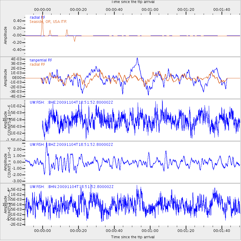
FISH Seaside, OR, USA - Earthquake Result Viewer
*The percent match for this event was below the threshold and hence no stack was calculated.
| Earthquake location: |
Azores Islands Region |
| Earthquake latitude/longitude: |
36.2/-33.9 |
| Earthquake time(UTC): |
2009/11/04 (308) 18:41:44 GMT |
| Earthquake Depth: |
10 km |
| Earthquake Magnitude: |
5.7 MB, 5.6 MS, 5.9 MW, 5.8 MW |
| Earthquake Catalog/Contributor: |
WHDF/NEIC |
|
| Network: |
UW Pacific Northwest Regional Seismic Network |
| Station: |
FISH Seaside, OR, USA |
| Lat/Lon: |
45.93 N/123.56 W |
| Elevation: |
325 m |
|
| Distance: |
64.9 deg |
| Az: |
309.599 deg |
| Baz: |
63.315 deg |
| Ray Param: |
$rayparam |
*The percent match for this event was below the threshold and hence was not used in the summary stack. |
|
| Radial Match: |
52.967445 % |
| Radial Bump: |
400 |
| Transverse Match: |
47.396408 % |
| Transverse Bump: |
400 |
| SOD ConfigId: |
2622 |
| Insert Time: |
2010-02-27 04:17:53.878 +0000 |
| GWidth: |
2.5 |
| Max Bumps: |
400 |
| Tol: |
0.001 |
|
Signal To Noise
| Channel | StoN | STA | LTA |
| UW:FISH: :BHZ:20091104T18:51:52.800002Z | 4.130262 | 1.4161253E-6 | 3.4286575E-7 |
| UW:FISH: :BHN:20091104T18:51:52.800002Z | 1.0308692 | 5.814596E-9 | 5.6404788E-9 |
| UW:FISH: :BHE:20091104T18:51:52.800002Z | 1.0645865 | 5.1088E-9 | 4.7988586E-9 |
| Arrivals |
| Ps | |
| PpPs | |
| PsPs/PpSs | |


