You are here: Home > Network List > UW - Pacific Northwest Regional Seismic Network Stations List
> Station FISH Seaside, OR, USA > Earthquake Result Viewer
FISH Seaside, OR, USA - Earthquake Result Viewer
*The percent match for this event was below the threshold and hence no stack was calculated.
| Earthquake location: |
Honduras |
| Earthquake latitude/longitude: |
15.8/-86.9 |
| Earthquake time(UTC): |
2009/06/08 (159) 05:13:14 GMT |
| Earthquake Depth: |
10 km |
| Earthquake Magnitude: |
5.5 MB, 4.9 MS, 5.4 MW, 5.4 MW |
| Earthquake Catalog/Contributor: |
WHDF/NEIC |
|
| Network: |
UW Pacific Northwest Regional Seismic Network |
| Station: |
FISH Seaside, OR, USA |
| Lat/Lon: |
45.93 N/123.56 W |
| Elevation: |
325 m |
|
| Distance: |
42.9 deg |
| Az: |
322.224 deg |
| Baz: |
122.329 deg |
| Ray Param: |
$rayparam |
*The percent match for this event was below the threshold and hence was not used in the summary stack. |
|
| Radial Match: |
68.90142 % |
| Radial Bump: |
400 |
| Transverse Match: |
74.87501 % |
| Transverse Bump: |
400 |
| SOD ConfigId: |
2648 |
| Insert Time: |
2010-02-27 04:18:16.057 +0000 |
| GWidth: |
2.5 |
| Max Bumps: |
400 |
| Tol: |
0.001 |
|
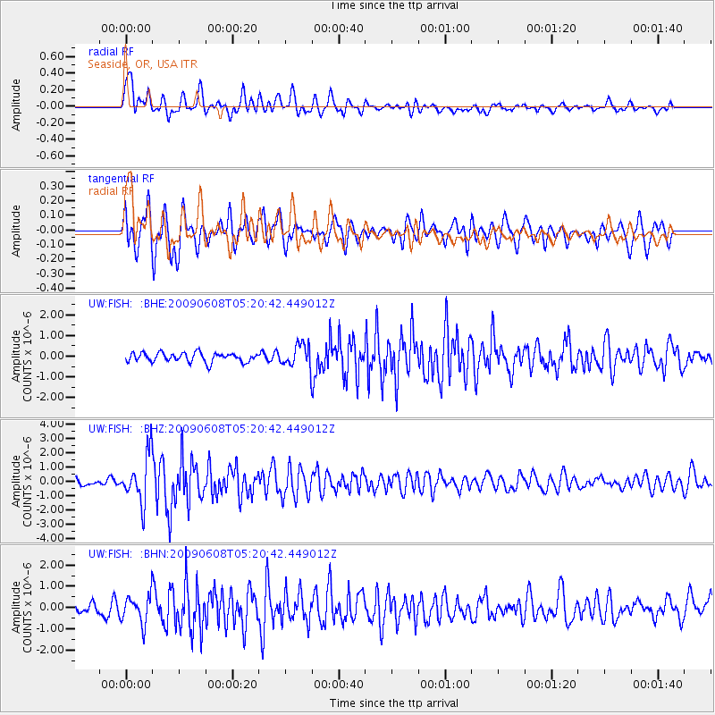
Signal To Noise
| Channel | StoN | STA | LTA |
| UW:FISH: :BHZ:20090608T05:20:42.449012Z | 6.2311783 | 1.6728429E-6 | 2.684633E-7 |
| UW:FISH: :BHN:20090608T05:20:42.449012Z | 1.8093363 | 6.6610687E-7 | 3.6814984E-7 |
| UW:FISH: :BHE:20090608T05:20:42.449012Z | 2.5844977 | 5.667588E-7 | 2.1929165E-7 |
| Arrivals |
| Ps | |
| PpPs | |
| PsPs/PpSs | |


