You are here: Home > Network List > UW - Pacific Northwest Regional Seismic Network Stations List
> Station FISH Seaside, OR, USA > Earthquake Result Viewer
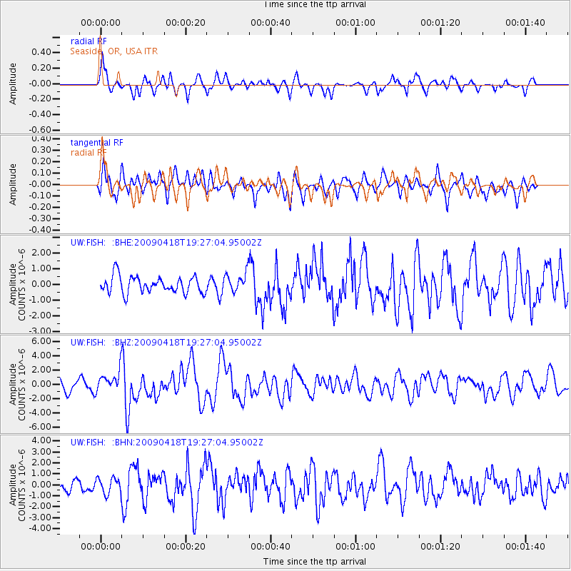
FISH Seaside, OR, USA - Earthquake Result Viewer
*The percent match for this event was below the threshold and hence no stack was calculated.
| Earthquake location: |
Kuril Islands |
| Earthquake latitude/longitude: |
46.0/151.4 |
| Earthquake time(UTC): |
2009/04/18 (108) 19:17:58 GMT |
| Earthquake Depth: |
35 km |
| Earthquake Magnitude: |
6.3 MB, 6.3 MS, 6.6 MW, 6.4 MW |
| Earthquake Catalog/Contributor: |
WHDF/NEIC |
|
| Network: |
UW Pacific Northwest Regional Seismic Network |
| Station: |
FISH Seaside, OR, USA |
| Lat/Lon: |
45.93 N/123.56 W |
| Elevation: |
325 m |
|
| Distance: |
56.2 deg |
| Az: |
56.766 deg |
| Baz: |
303.366 deg |
| Ray Param: |
$rayparam |
*The percent match for this event was below the threshold and hence was not used in the summary stack. |
|
| Radial Match: |
63.385853 % |
| Radial Bump: |
357 |
| Transverse Match: |
69.20859 % |
| Transverse Bump: |
400 |
| SOD ConfigId: |
2658 |
| Insert Time: |
2010-02-27 04:18:18.234 +0000 |
| GWidth: |
2.5 |
| Max Bumps: |
400 |
| Tol: |
0.001 |
|
Signal To Noise
| Channel | StoN | STA | LTA |
| UW:FISH: :BHZ:20090418T19:27:04.95002Z | 2.1337838 | 1.5125235E-6 | 7.088456E-7 |
| UW:FISH: :BHN:20090418T19:27:04.95002Z | 0.814206 | 7.3743007E-7 | 9.0570455E-7 |
| UW:FISH: :BHE:20090418T19:27:04.95002Z | 1.2125684 | 6.455472E-7 | 5.3238E-7 |
| Arrivals |
| Ps | |
| PpPs | |
| PsPs/PpSs | |


