You are here: Home > Network List > CN - Canadian National Seismograph Network Stations List
> Station INK INUVIK, NT > Earthquake Result Viewer
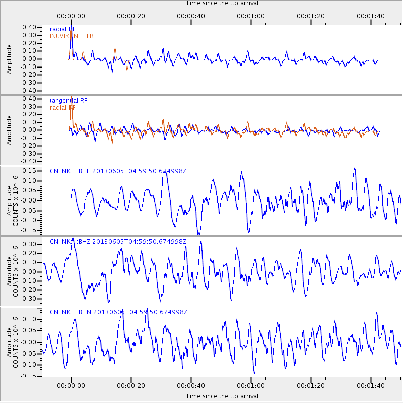
INK INUVIK, NT - Earthquake Result Viewer
*The percent match for this event was below the threshold and hence no stack was calculated.
| Earthquake location: |
Santa Cruz Islands |
| Earthquake latitude/longitude: |
-11.4/166.3 |
| Earthquake time(UTC): |
2013/06/05 (156) 04:47:26 GMT |
| Earthquake Depth: |
39 km |
| Earthquake Magnitude: |
6.1 MW, 5.8 MS, 5.9 MB, 6.1 MW |
| Earthquake Catalog/Contributor: |
NEIC PDE/NEIC PDE-W |
|
| Network: |
CN Canadian National Seismograph Network |
| Station: |
INK INUVIK, NT |
| Lat/Lon: |
68.31 N/133.53 W |
| Elevation: |
44 m |
|
| Distance: |
90.1 deg |
| Az: |
18.817 deg |
| Baz: |
238.283 deg |
| Ray Param: |
$rayparam |
*The percent match for this event was below the threshold and hence was not used in the summary stack. |
|
| Radial Match: |
78.82812 % |
| Radial Bump: |
291 |
| Transverse Match: |
47.237366 % |
| Transverse Bump: |
400 |
| SOD ConfigId: |
512894 |
| Insert Time: |
2013-09-15 00:39:39.092 +0000 |
| GWidth: |
2.5 |
| Max Bumps: |
400 |
| Tol: |
0.001 |
|
Signal To Noise
| Channel | StoN | STA | LTA |
| CN:INK: :BHZ:20130605T04:59:50.674998Z | 3.7072818 | 2.29291E-7 | 6.1848816E-8 |
| CN:INK: :BHN:20130605T04:59:50.674998Z | 1.3297489 | 5.9393216E-8 | 4.466499E-8 |
| CN:INK: :BHE:20130605T04:59:50.674998Z | 2.5807705 | 9.7989535E-8 | 3.79691E-8 |
| Arrivals |
| Ps | |
| PpPs | |
| PsPs/PpSs | |


