You are here: Home > Network List > UW - Pacific Northwest Regional Seismic Network Stations List
> Station FISH Seaside, OR, USA > Earthquake Result Viewer
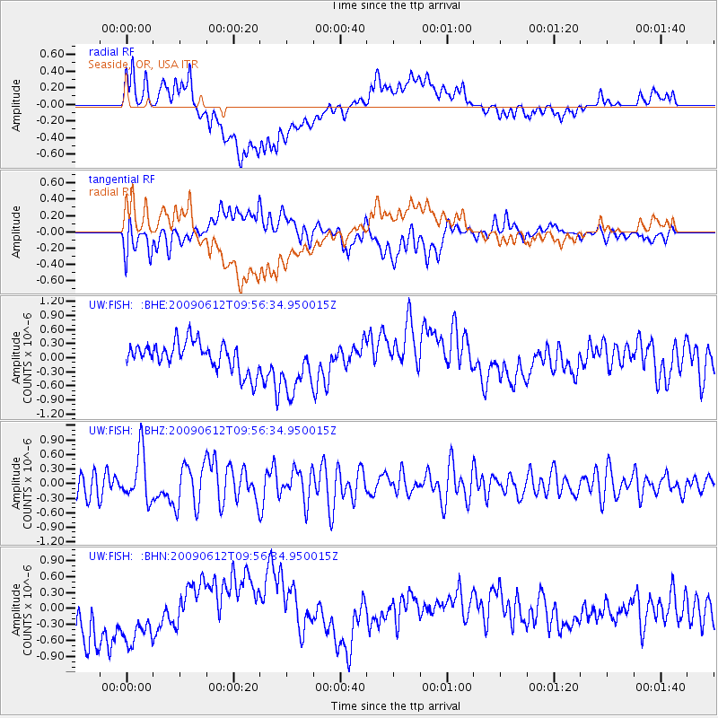
FISH Seaside, OR, USA - Earthquake Result Viewer
*The percent match for this event was below the threshold and hence no stack was calculated.
| Earthquake location: |
Vanuatu Islands |
| Earthquake latitude/longitude: |
-17.6/167.8 |
| Earthquake time(UTC): |
2009/06/12 (163) 09:44:15 GMT |
| Earthquake Depth: |
15 km |
| Earthquake Magnitude: |
5.5 MB, 5.6 MS, 6.0 MW, 6.0 MW |
| Earthquake Catalog/Contributor: |
WHDF/NEIC |
|
| Network: |
UW Pacific Northwest Regional Seismic Network |
| Station: |
FISH Seaside, OR, USA |
| Lat/Lon: |
45.93 N/123.56 W |
| Elevation: |
325 m |
|
| Distance: |
88.4 deg |
| Az: |
40.556 deg |
| Baz: |
242.681 deg |
| Ray Param: |
$rayparam |
*The percent match for this event was below the threshold and hence was not used in the summary stack. |
|
| Radial Match: |
46.232563 % |
| Radial Bump: |
400 |
| Transverse Match: |
58.675797 % |
| Transverse Bump: |
400 |
| SOD ConfigId: |
2648 |
| Insert Time: |
2010-02-27 04:18:35.181 +0000 |
| GWidth: |
2.5 |
| Max Bumps: |
400 |
| Tol: |
0.001 |
|
Signal To Noise
| Channel | StoN | STA | LTA |
| UW:FISH: :BHZ:20090612T09:56:34.950015Z | 2.3694956 | 5.0499807E-7 | 2.1312471E-7 |
| UW:FISH: :BHN:20090612T09:56:34.950015Z | 1.2406852 | 6.243096E-7 | 5.0319744E-7 |
| UW:FISH: :BHE:20090612T09:56:34.950015Z | 1.942223 | 5.931584E-7 | 3.0540178E-7 |
| Arrivals |
| Ps | |
| PpPs | |
| PsPs/PpSs | |


