You are here: Home > Network List > TA - USArray Transportable Network (new EarthScope stations) Stations List
> Station G05D Wamic, OR, USA > Earthquake Result Viewer
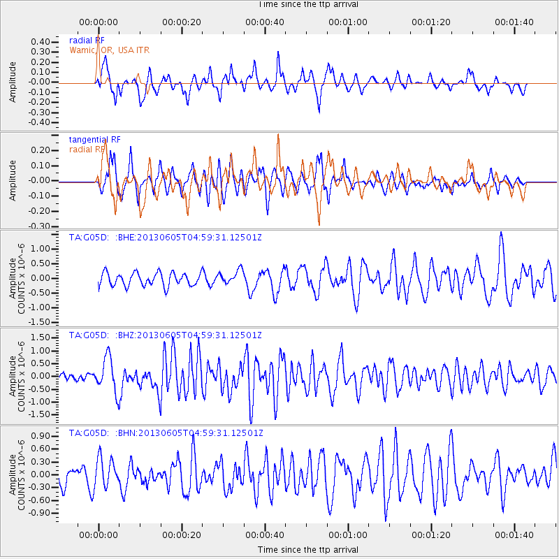
G05D Wamic, OR, USA - Earthquake Result Viewer
*The percent match for this event was below the threshold and hence no stack was calculated.
| Earthquake location: |
Santa Cruz Islands |
| Earthquake latitude/longitude: |
-11.4/166.3 |
| Earthquake time(UTC): |
2013/06/05 (156) 04:47:26 GMT |
| Earthquake Depth: |
39 km |
| Earthquake Magnitude: |
6.1 MW, 5.8 MS, 5.9 MB, 6.1 MW |
| Earthquake Catalog/Contributor: |
NEIC PDE/NEIC PDE-W |
|
| Network: |
TA USArray Transportable Network (new EarthScope stations) |
| Station: |
G05D Wamic, OR, USA |
| Lat/Lon: |
45.24 N/121.32 W |
| Elevation: |
592 m |
|
| Distance: |
85.9 deg |
| Az: |
42.458 deg |
| Baz: |
249.535 deg |
| Ray Param: |
$rayparam |
*The percent match for this event was below the threshold and hence was not used in the summary stack. |
|
| Radial Match: |
71.65862 % |
| Radial Bump: |
346 |
| Transverse Match: |
68.02768 % |
| Transverse Bump: |
334 |
| SOD ConfigId: |
512894 |
| Insert Time: |
2013-09-15 00:48:09.765 +0000 |
| GWidth: |
2.5 |
| Max Bumps: |
400 |
| Tol: |
0.001 |
|
Signal To Noise
| Channel | StoN | STA | LTA |
| TA:G05D: :BHZ:20130605T04:59:31.12501Z | 3.544097 | 6.881381E-7 | 1.9416458E-7 |
| TA:G05D: :BHN:20130605T04:59:31.12501Z | 1.4561836 | 3.3670207E-7 | 2.3122227E-7 |
| TA:G05D: :BHE:20130605T04:59:31.12501Z | 1.0939672 | 2.423011E-7 | 2.2148845E-7 |
| Arrivals |
| Ps | |
| PpPs | |
| PsPs/PpSs | |


