You are here: Home > Network List > TA - USArray Transportable Network (new EarthScope stations) Stations List
> Station H17A Grant Village (NPS), Yellowstone Nt. Park, WY, USA > Earthquake Result Viewer
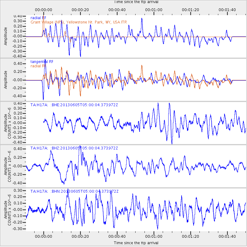
H17A Grant Village (NPS), Yellowstone Nt. Park, WY, USA - Earthquake Result Viewer
*The percent match for this event was below the threshold and hence no stack was calculated.
| Earthquake location: |
Santa Cruz Islands |
| Earthquake latitude/longitude: |
-11.4/166.3 |
| Earthquake time(UTC): |
2013/06/05 (156) 04:47:26 GMT |
| Earthquake Depth: |
39 km |
| Earthquake Magnitude: |
6.1 MW, 5.8 MS, 5.9 MB, 6.1 MW |
| Earthquake Catalog/Contributor: |
NEIC PDE/NEIC PDE-W |
|
| Network: |
TA USArray Transportable Network (new EarthScope stations) |
| Station: |
H17A Grant Village (NPS), Yellowstone Nt. Park, WY, USA |
| Lat/Lon: |
44.40 N/110.58 W |
| Elevation: |
2400 m |
|
| Distance: |
93.0 deg |
| Az: |
45.456 deg |
| Baz: |
257.118 deg |
| Ray Param: |
$rayparam |
*The percent match for this event was below the threshold and hence was not used in the summary stack. |
|
| Radial Match: |
68.80629 % |
| Radial Bump: |
400 |
| Transverse Match: |
64.83148 % |
| Transverse Bump: |
400 |
| SOD ConfigId: |
512894 |
| Insert Time: |
2013-09-15 00:48:16.878 +0000 |
| GWidth: |
2.5 |
| Max Bumps: |
400 |
| Tol: |
0.001 |
|
Signal To Noise
| Channel | StoN | STA | LTA |
| TA:H17A: :BHZ:20130605T05:00:04.373972Z | 3.68886 | 1.7597293E-7 | 4.7703878E-8 |
| TA:H17A: :BHN:20130605T05:00:04.373972Z | 1.330048 | 8.7042224E-8 | 6.5442926E-8 |
| TA:H17A: :BHE:20130605T05:00:04.373972Z | 0.9080715 | 8.013613E-8 | 8.8248704E-8 |
| Arrivals |
| Ps | |
| PpPs | |
| PsPs/PpSs | |


