You are here: Home > Network List > US - United States National Seismic Network Stations List
> Station HAWA Hanford, Washington, USA > Earthquake Result Viewer
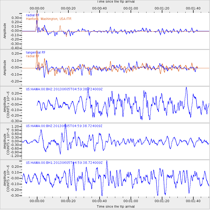
HAWA Hanford, Washington, USA - Earthquake Result Viewer
*The percent match for this event was below the threshold and hence no stack was calculated.
| Earthquake location: |
Santa Cruz Islands |
| Earthquake latitude/longitude: |
-11.4/166.3 |
| Earthquake time(UTC): |
2013/06/05 (156) 04:47:26 GMT |
| Earthquake Depth: |
39 km |
| Earthquake Magnitude: |
6.1 MW, 5.8 MS, 5.9 MB, 6.1 MW |
| Earthquake Catalog/Contributor: |
NEIC PDE/NEIC PDE-W |
|
| Network: |
US United States National Seismic Network |
| Station: |
HAWA Hanford, Washington, USA |
| Lat/Lon: |
46.39 N/119.53 W |
| Elevation: |
364 m |
|
| Distance: |
87.5 deg |
| Az: |
41.798 deg |
| Baz: |
250.773 deg |
| Ray Param: |
$rayparam |
*The percent match for this event was below the threshold and hence was not used in the summary stack. |
|
| Radial Match: |
76.31355 % |
| Radial Bump: |
400 |
| Transverse Match: |
77.68185 % |
| Transverse Bump: |
400 |
| SOD ConfigId: |
512894 |
| Insert Time: |
2013-09-15 00:50:32.177 +0000 |
| GWidth: |
2.5 |
| Max Bumps: |
400 |
| Tol: |
0.001 |
|
Signal To Noise
| Channel | StoN | STA | LTA |
| US:HAWA:00:BHZ:20130605T04:59:38.724009Z | 5.3022847 | 4.5703575E-7 | 8.6196E-8 |
| US:HAWA:00:BH1:20130605T04:59:38.724009Z | 1.3809539 | 6.0091146E-8 | 4.351423E-8 |
| US:HAWA:00:BH2:20130605T04:59:38.724009Z | 2.5289629 | 1.3969527E-7 | 5.5238168E-8 |
| Arrivals |
| Ps | |
| PpPs | |
| PsPs/PpSs | |


