You are here: Home > Network List > G - GEOSCOPE Stations List
> Station INU Inuyama, Japan > Earthquake Result Viewer
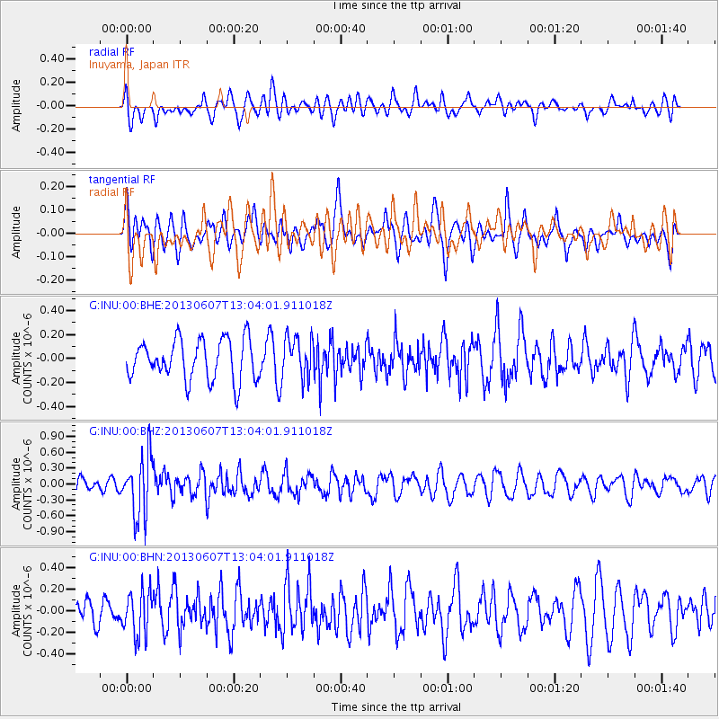
INU Inuyama, Japan - Earthquake Result Viewer
*The percent match for this event was below the threshold and hence no stack was calculated.
| Earthquake location: |
South Of Fiji Islands |
| Earthquake latitude/longitude: |
-23.9/179.1 |
| Earthquake time(UTC): |
2013/06/07 (158) 12:54:09 GMT |
| Earthquake Depth: |
546 km |
| Earthquake Magnitude: |
5.9 MW, 5.5 MB, 5.9 MW |
| Earthquake Catalog/Contributor: |
NEIC PDE/NEIC PDE-W |
|
| Network: |
G GEOSCOPE |
| Station: |
INU Inuyama, Japan |
| Lat/Lon: |
35.35 N/137.03 E |
| Elevation: |
132 m |
|
| Distance: |
71.1 deg |
| Az: |
324.639 deg |
| Baz: |
139.607 deg |
| Ray Param: |
$rayparam |
*The percent match for this event was below the threshold and hence was not used in the summary stack. |
|
| Radial Match: |
58.38886 % |
| Radial Bump: |
400 |
| Transverse Match: |
45.70146 % |
| Transverse Bump: |
400 |
| SOD ConfigId: |
512894 |
| Insert Time: |
2013-09-15 01:04:06.446 +0000 |
| GWidth: |
2.5 |
| Max Bumps: |
400 |
| Tol: |
0.001 |
|
Signal To Noise
| Channel | StoN | STA | LTA |
| G:INU:00:BHZ:20130607T13:04:01.911018Z | 4.741691 | 5.7313287E-7 | 1.2087098E-7 |
| G:INU:00:BHN:20130607T13:04:01.911018Z | 1.6012689 | 2.0666769E-7 | 1.2906496E-7 |
| G:INU:00:BHE:20130607T13:04:01.911018Z | 1.0104681 | 1.6977401E-7 | 1.680152E-7 |
| Arrivals |
| Ps | |
| PpPs | |
| PsPs/PpSs | |


