You are here: Home > Network List > TA - USArray Transportable Network (new EarthScope stations) Stations List
> Station J04D Umpqua National Forest, Toketee, OR, USA > Earthquake Result Viewer
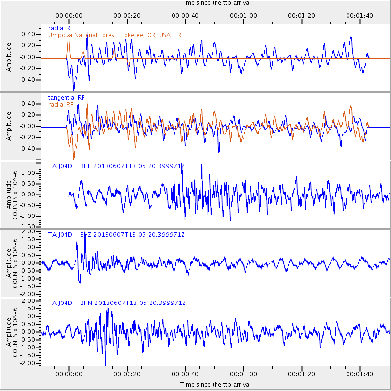
J04D Umpqua National Forest, Toketee, OR, USA - Earthquake Result Viewer
*The percent match for this event was below the threshold and hence no stack was calculated.
| Earthquake location: |
South Of Fiji Islands |
| Earthquake latitude/longitude: |
-23.9/179.1 |
| Earthquake time(UTC): |
2013/06/07 (158) 12:54:09 GMT |
| Earthquake Depth: |
546 km |
| Earthquake Magnitude: |
5.9 MW, 5.5 MB, 5.9 MW |
| Earthquake Catalog/Contributor: |
NEIC PDE/NEIC PDE-W |
|
| Network: |
TA USArray Transportable Network (new EarthScope stations) |
| Station: |
J04D Umpqua National Forest, Toketee, OR, USA |
| Lat/Lon: |
43.24 N/122.11 W |
| Elevation: |
1948 m |
|
| Distance: |
85.9 deg |
| Az: |
38.809 deg |
| Baz: |
231.722 deg |
| Ray Param: |
$rayparam |
*The percent match for this event was below the threshold and hence was not used in the summary stack. |
|
| Radial Match: |
63.808723 % |
| Radial Bump: |
400 |
| Transverse Match: |
69.27654 % |
| Transverse Bump: |
400 |
| SOD ConfigId: |
512894 |
| Insert Time: |
2013-09-15 01:12:52.651 +0000 |
| GWidth: |
2.5 |
| Max Bumps: |
400 |
| Tol: |
0.001 |
|
Signal To Noise
| Channel | StoN | STA | LTA |
| TA:J04D: :BHZ:20130607T13:05:20.399971Z | 3.4097965 | 5.705801E-7 | 1.6733551E-7 |
| TA:J04D: :BHN:20130607T13:05:20.399971Z | 1.4423658 | 3.120139E-7 | 2.1632094E-7 |
| TA:J04D: :BHE:20130607T13:05:20.399971Z | 1.1248289 | 3.2135225E-7 | 2.8568988E-7 |
| Arrivals |
| Ps | |
| PpPs | |
| PsPs/PpSs | |


