You are here: Home > Network List > UW - Pacific Northwest Regional Seismic Network Stations List
> Station GNW Green Mountain (BB) > Earthquake Result Viewer
GNW Green Mountain (BB) - Earthquake Result Viewer
| Earthquake location: |
Northwest Of Kuril Islands |
| Earthquake latitude/longitude: |
47.4/147.0 |
| Earthquake time(UTC): |
2006/12/09 (343) 14:48:55 GMT |
| Earthquake Depth: |
405 km |
| Earthquake Magnitude: |
5.6 MB, 5.8 MW, 5.8 MW |
| Earthquake Catalog/Contributor: |
WHDF/NEIC |
|
| Network: |
UW Pacific Northwest Regional Seismic Network |
| Station: |
GNW Green Mountain (BB) |
| Lat/Lon: |
47.56 N/122.83 W |
| Elevation: |
160 m |
|
| Distance: |
57.4 deg |
| Az: |
53.518 deg |
| Baz: |
306.294 deg |
| Ray Param: |
0.062016357 |
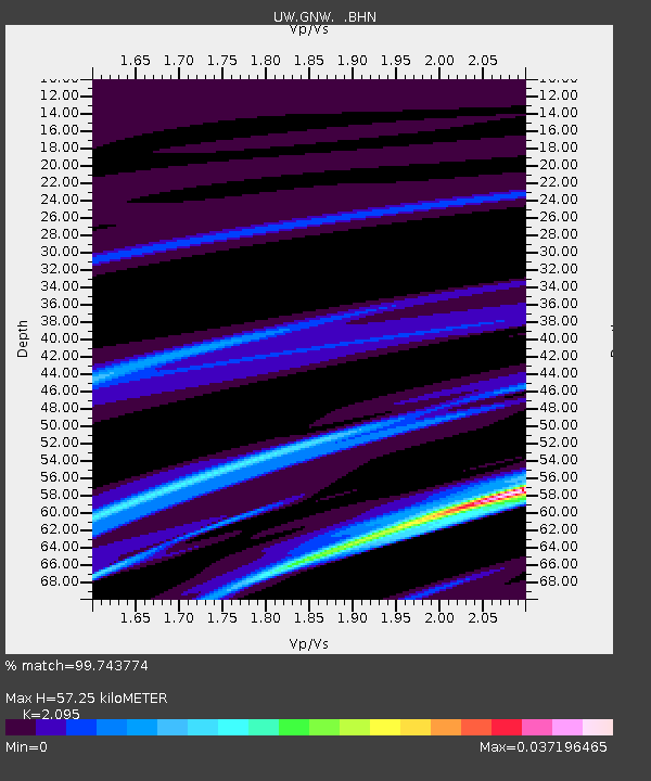
| Estimated Moho Depth: |
57.25 km |
| Estimated Crust Vp/Vs: |
2.10 |
| Assumed Crust Vp: |
6.566 km/s |
| Estimated Crust Vs: |
3.134 km/s |
| Estimated Crust Poisson's Ratio: |
0.35 |
|
| Radial Match: |
99.743774 % |
| Radial Bump: |
34 |
| Transverse Match: |
99.17999 % |
| Transverse Bump: |
54 |
| SOD ConfigId: |
2564 |
| Insert Time: |
2010-02-27 04:19:31.817 +0000 |
| GWidth: |
2.5 |
| Max Bumps: |
400 |
| Tol: |
0.001 |
|

Signal To Noise
| Channel | StoN | STA | LTA |
| UW:GNW: :BHN:20061209T14:57:32.098022Z | 0.395484 | 2.2934823E-7 | 5.799178E-7 |
| UW:GNW: :BHE:20061209T14:57:32.098022Z | 0.7017289 | 2.1248692E-7 | 3.0280486E-7 |
| UW:GNW: :BHZ:20061209T14:57:32.098022Z | 0.68311197 | 1.8966378E-7 | 2.7764668E-7 |
| Arrivals |
| Ps | 10.0 SECOND |
| PpPs | 26 SECOND |
| PsPs/PpSs | 36 SECOND |


