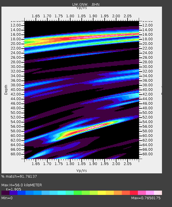
GNW Green Mountain (BB) - Earthquake Result Viewer
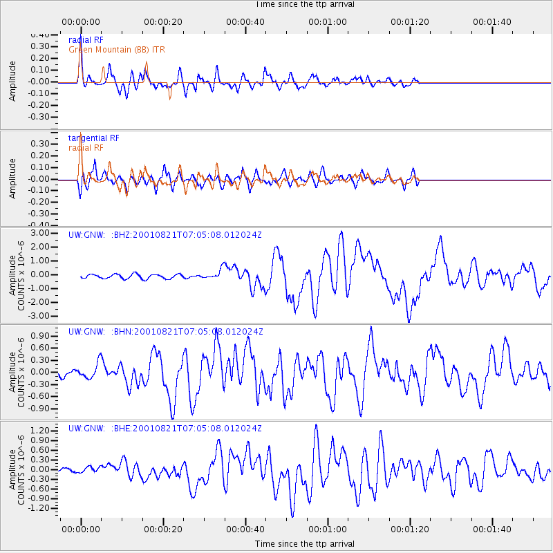
Earthquake location: East Of North Island, N.Z.
Earthquake latitude/longitude: -36.8/-179.6
Earthquake time(UTC): 2001/08/21 (233) 06:52:06 GMT
Earthquake Depth: 33 km
Earthquake Magnitude: 6.4 MB, 7.1 MS, 7.2 ME, 7.0 ML
Earthquake Catalog/Contributor: WHDF/NEIC
Network: UW Pacific Northwest Regional Seismic Network
Station: GNW Green Mountain (BB)
Lat/Lon: 47.56 N/122.83 W
Elevation: 160 m
Distance: 98.1 deg
Az: 34.895 deg
Baz: 222.68 deg
Ray Param: 0.03999027
Estimated Moho Depth: 56.0 km
Estimated Crust Vp/Vs: 1.90
Assumed Crust Vp: 6.566 km/s
Estimated Crust Vs: 3.447 km/s
Estimated Crust Poisson's Ratio: 0.31
Radial Match: 91.76137 %
Radial Bump: 400
Transverse Match: 85.39088 %
Transverse Bump: 400
SOD ConfigId: 20082
Insert Time: 2010-02-27 04:19:36.907 +0000
GWidth: 2.5
Max Bumps: 400
Tol: 0.001

Signal To Noise

ChannelStoNSTALTA
UW:GNW: :BHN:20010821T07:05:08.012024Z2.3830271.8726473E-77.858271E-8
UW:GNW: :BHE:20010821T07:05:08.012024Z1.36216781.126071E-78.266757E-8
UW:GNW: :BHZ:20010821T07:05:08.012024Z2.30237413.6403293E-71.5811197E-7
Arrivals
Ps7.9 SECOND
PpPs24 SECOND
PsPs/PpSs32 SECOND