You are here: Home > Network List > UW - Pacific Northwest Regional Seismic Network Stations List
> Station GNW Green Mountain (BB) > Earthquake Result Viewer
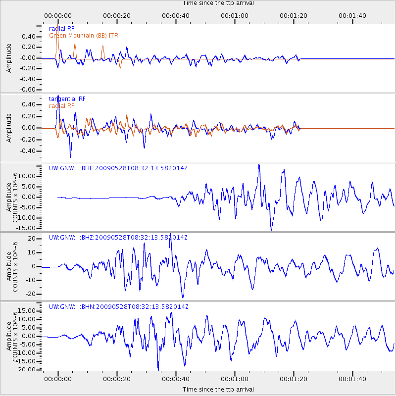
GNW Green Mountain (BB) - Earthquake Result Viewer
*The percent match for this event was below the threshold and hence no stack was calculated.
| Earthquake location: |
North Of Honduras |
| Earthquake latitude/longitude: |
16.7/-86.2 |
| Earthquake time(UTC): |
2009/05/28 (148) 08:24:45 GMT |
| Earthquake Depth: |
10 km |
| Earthquake Magnitude: |
6.7 MB, 7.2 MS, 7.3 MW, 7.3 MW |
| Earthquake Catalog/Contributor: |
WHDF/NEIC |
|
| Network: |
UW Pacific Northwest Regional Seismic Network |
| Station: |
GNW Green Mountain (BB) |
| Lat/Lon: |
47.56 N/122.83 W |
| Elevation: |
160 m |
|
| Distance: |
43.0 deg |
| Az: |
323.7 deg |
| Baz: |
123.105 deg |
| Ray Param: |
$rayparam |
*The percent match for this event was below the threshold and hence was not used in the summary stack. |
|
| Radial Match: |
78.982895 % |
| Radial Bump: |
400 |
| Transverse Match: |
88.871765 % |
| Transverse Bump: |
290 |
| SOD ConfigId: |
2648 |
| Insert Time: |
2010-02-27 04:21:08.694 +0000 |
| GWidth: |
2.5 |
| Max Bumps: |
400 |
| Tol: |
0.001 |
|
Signal To Noise
| Channel | StoN | STA | LTA |
| UW:GNW: :BHZ:20090528T08:32:13.582014Z | 14.714596 | 1.4073241E-6 | 9.564137E-8 |
| UW:GNW: :BHN:20090528T08:32:13.582014Z | 5.4628572 | 6.8548843E-7 | 1.2548166E-7 |
| UW:GNW: :BHE:20090528T08:32:13.582014Z | 2.348936 | 4.7551205E-7 | 2.0243719E-7 |
| Arrivals |
| Ps | |
| PpPs | |
| PsPs/PpSs | |


