You are here: Home > Network List > TA - USArray Transportable Network (new EarthScope stations) Stations List
> Station D41A Chassel, MI, USA > Earthquake Result Viewer
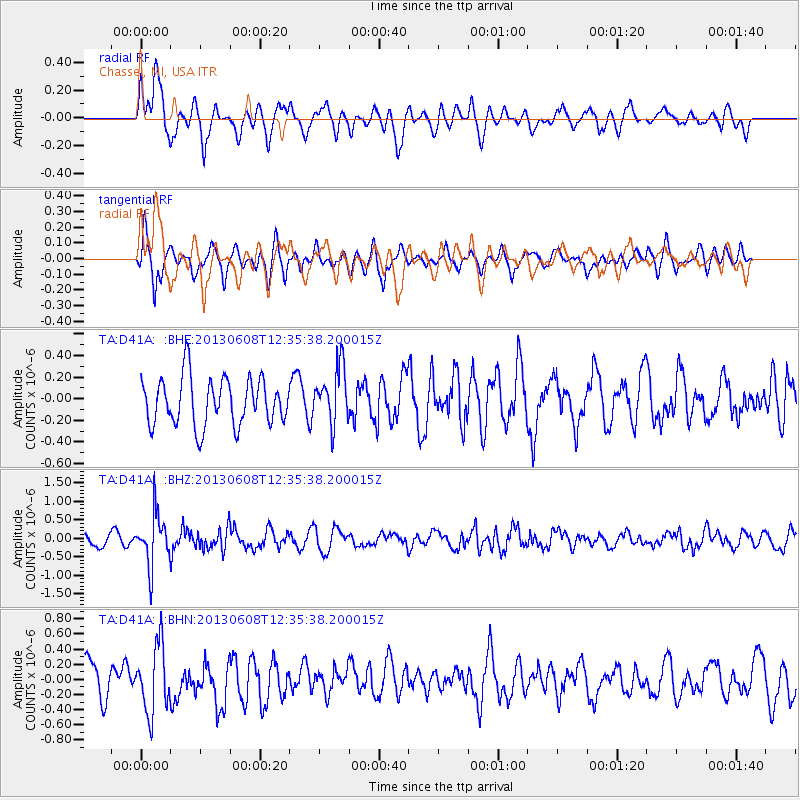
D41A Chassel, MI, USA - Earthquake Result Viewer
*The percent match for this event was below the threshold and hence no stack was calculated.
| Earthquake location: |
Jujuy Province, Argentina |
| Earthquake latitude/longitude: |
-22.6/-66.7 |
| Earthquake time(UTC): |
2013/06/08 (159) 12:25:08 GMT |
| Earthquake Depth: |
215 km |
| Earthquake Magnitude: |
5.6 MW, 5.5 MB, 5.6 MW |
| Earthquake Catalog/Contributor: |
NEIC PDE/NEIC PDE-W |
|
| Network: |
TA USArray Transportable Network (new EarthScope stations) |
| Station: |
D41A Chassel, MI, USA |
| Lat/Lon: |
47.06 N/88.57 W |
| Elevation: |
271 m |
|
| Distance: |
72.1 deg |
| Az: |
344.472 deg |
| Baz: |
158.784 deg |
| Ray Param: |
$rayparam |
*The percent match for this event was below the threshold and hence was not used in the summary stack. |
|
| Radial Match: |
62.401485 % |
| Radial Bump: |
400 |
| Transverse Match: |
55.678535 % |
| Transverse Bump: |
371 |
| SOD ConfigId: |
512894 |
| Insert Time: |
2013-09-15 02:26:58.760 +0000 |
| GWidth: |
2.5 |
| Max Bumps: |
400 |
| Tol: |
0.001 |
|
Signal To Noise
| Channel | StoN | STA | LTA |
| TA:D41A: :BHZ:20130608T12:35:38.200015Z | 5.4234185 | 6.841719E-7 | 1.261514E-7 |
| TA:D41A: :BHN:20130608T12:35:38.200015Z | 2.7096956 | 4.437591E-7 | 1.6376713E-7 |
| TA:D41A: :BHE:20130608T12:35:38.200015Z | 1.1903074 | 2.6240002E-7 | 2.2044726E-7 |
| Arrivals |
| Ps | |
| PpPs | |
| PsPs/PpSs | |


