You are here: Home > Network List > TA - USArray Transportable Network (new EarthScope stations) Stations List
> Station D48A Paudash Township, ON, CAN > Earthquake Result Viewer
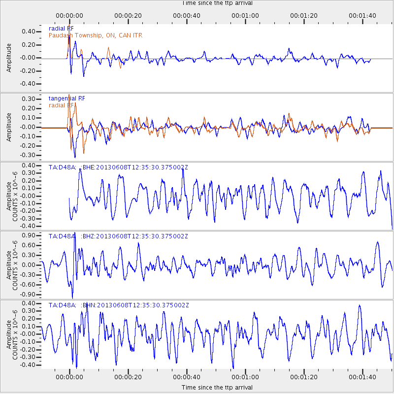
D48A Paudash Township, ON, CAN - Earthquake Result Viewer
*The percent match for this event was below the threshold and hence no stack was calculated.
| Earthquake location: |
Jujuy Province, Argentina |
| Earthquake latitude/longitude: |
-22.6/-66.7 |
| Earthquake time(UTC): |
2013/06/08 (159) 12:25:08 GMT |
| Earthquake Depth: |
215 km |
| Earthquake Magnitude: |
5.6 MW, 5.5 MB, 5.6 MW |
| Earthquake Catalog/Contributor: |
NEIC PDE/NEIC PDE-W |
|
| Network: |
TA USArray Transportable Network (new EarthScope stations) |
| Station: |
D48A Paudash Township, ON, CAN |
| Lat/Lon: |
47.17 N/81.81 W |
| Elevation: |
434 m |
|
| Distance: |
70.8 deg |
| Az: |
349.139 deg |
| Baz: |
165.211 deg |
| Ray Param: |
$rayparam |
*The percent match for this event was below the threshold and hence was not used in the summary stack. |
|
| Radial Match: |
75.91926 % |
| Radial Bump: |
400 |
| Transverse Match: |
59.13325 % |
| Transverse Bump: |
400 |
| SOD ConfigId: |
512894 |
| Insert Time: |
2013-09-15 02:27:04.654 +0000 |
| GWidth: |
2.5 |
| Max Bumps: |
400 |
| Tol: |
0.001 |
|
Signal To Noise
| Channel | StoN | STA | LTA |
| TA:D48A: :BHZ:20130608T12:35:30.375002Z | 1.9497064 | 5.3016515E-7 | 2.719205E-7 |
| TA:D48A: :BHN:20130608T12:35:30.375002Z | 1.5190845 | 1.8918524E-7 | 1.2453899E-7 |
| TA:D48A: :BHE:20130608T12:35:30.375002Z | 0.7696787 | 1.2868868E-7 | 1.6719792E-7 |
| Arrivals |
| Ps | |
| PpPs | |
| PsPs/PpSs | |


