You are here: Home > Network List > TA - USArray Transportable Network (new EarthScope stations) Stations List
> Station O03E Paynes Creek, CA, USA > Earthquake Result Viewer
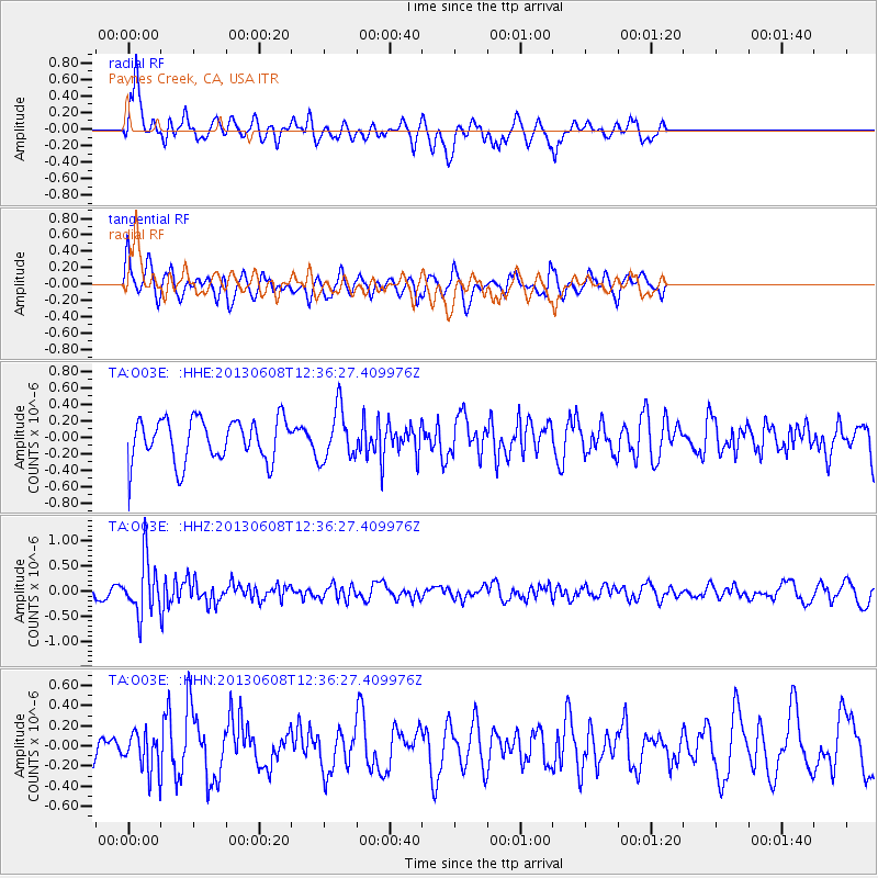
O03E Paynes Creek, CA, USA - Earthquake Result Viewer
*The percent match for this event was below the threshold and hence no stack was calculated.
| Earthquake location: |
Jujuy Province, Argentina |
| Earthquake latitude/longitude: |
-22.6/-66.7 |
| Earthquake time(UTC): |
2013/06/08 (159) 12:25:08 GMT |
| Earthquake Depth: |
215 km |
| Earthquake Magnitude: |
5.6 MW, 5.5 MB, 5.6 MW |
| Earthquake Catalog/Contributor: |
NEIC PDE/NEIC PDE-W |
|
| Network: |
TA USArray Transportable Network (new EarthScope stations) |
| Station: |
O03E Paynes Creek, CA, USA |
| Lat/Lon: |
40.29 N/121.80 W |
| Elevation: |
967 m |
|
| Distance: |
80.9 deg |
| Az: |
320.55 deg |
| Baz: |
129.846 deg |
| Ray Param: |
$rayparam |
*The percent match for this event was below the threshold and hence was not used in the summary stack. |
|
| Radial Match: |
67.728966 % |
| Radial Bump: |
375 |
| Transverse Match: |
51.293533 % |
| Transverse Bump: |
395 |
| SOD ConfigId: |
512894 |
| Insert Time: |
2013-09-15 02:33:00.458 +0000 |
| GWidth: |
2.5 |
| Max Bumps: |
400 |
| Tol: |
0.001 |
|
Signal To Noise
| Channel | StoN | STA | LTA |
| TA:O03E: :HHZ:20130608T12:36:27.409976Z | 3.7851882 | 5.436828E-7 | 1.4363428E-7 |
| TA:O03E: :HHN:20130608T12:36:27.409976Z | 1.080173 | 1.8160526E-7 | 1.6812606E-7 |
| TA:O03E: :HHE:20130608T12:36:27.409976Z | 1.1840183 | 3.133673E-7 | 2.6466424E-7 |
| Arrivals |
| Ps | |
| PpPs | |
| PsPs/PpSs | |


