You are here: Home > Network List > US - United States National Seismic Network Stations List
> Station DGMT Dagmar, Montana, USA > Earthquake Result Viewer
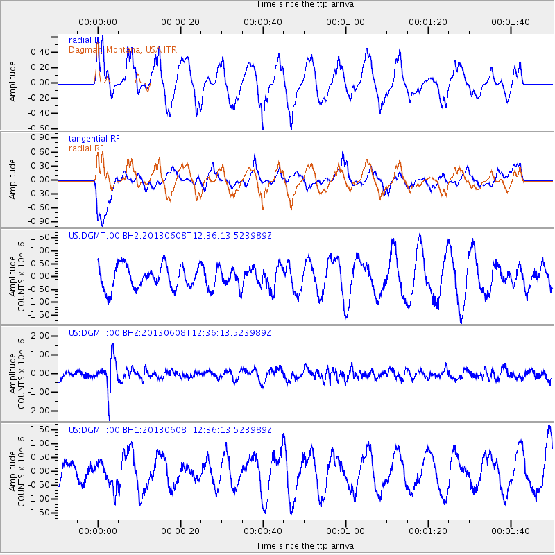
DGMT Dagmar, Montana, USA - Earthquake Result Viewer
*The percent match for this event was below the threshold and hence no stack was calculated.
| Earthquake location: |
Jujuy Province, Argentina |
| Earthquake latitude/longitude: |
-22.6/-66.7 |
| Earthquake time(UTC): |
2013/06/08 (159) 12:25:08 GMT |
| Earthquake Depth: |
215 km |
| Earthquake Magnitude: |
5.6 MW, 5.5 MB, 5.6 MW |
| Earthquake Catalog/Contributor: |
NEIC PDE/NEIC PDE-W |
|
| Network: |
US United States National Seismic Network |
| Station: |
DGMT Dagmar, Montana, USA |
| Lat/Lon: |
48.47 N/104.20 W |
| Elevation: |
0.0 m |
|
| Distance: |
78.3 deg |
| Az: |
335.558 deg |
| Baz: |
144.927 deg |
| Ray Param: |
$rayparam |
*The percent match for this event was below the threshold and hence was not used in the summary stack. |
|
| Radial Match: |
41.37208 % |
| Radial Bump: |
308 |
| Transverse Match: |
49.068985 % |
| Transverse Bump: |
400 |
| SOD ConfigId: |
512894 |
| Insert Time: |
2013-09-15 02:40:56.431 +0000 |
| GWidth: |
2.5 |
| Max Bumps: |
400 |
| Tol: |
0.001 |
|
Signal To Noise
| Channel | StoN | STA | LTA |
| US:DGMT:00:BHZ:20130608T12:36:13.523989Z | 4.209475 | 8.788729E-7 | 2.0878444E-7 |
| US:DGMT:00:BH1:20130608T12:36:13.523989Z | 0.9945515 | 4.4209796E-7 | 4.4451994E-7 |
| US:DGMT:00:BH2:20130608T12:36:13.523989Z | 0.81057435 | 3.5195143E-7 | 4.3420005E-7 |
| Arrivals |
| Ps | |
| PpPs | |
| PsPs/PpSs | |


