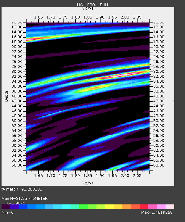
HEBO Mt. Hebo, OR CREST BB SMO - Earthquake Result Viewer

Earthquake location: Near Coast Of Chiapas, Mexico
Earthquake latitude/longitude: 14.4/-92.4
Earthquake time(UTC): 2008/10/16 (290) 19:41:25 GMT
Earthquake Depth: 24 km
Earthquake Magnitude: 6.1 MB, 6.6 MS, 6.7 MW, 6.6 MW
Earthquake Catalog/Contributor: WHDF/NEIC
Network: UW Pacific Northwest Regional Seismic Network
Station: HEBO Mt. Hebo, OR CREST BB SMO
Lat/Lon: 45.21 N/123.76 W
Elevation: 875 m
Distance: 40.6 deg
Az: 325.515 deg
Baz: 129.097 deg
Ray Param: 0.07429152
Estimated Moho Depth: 31.25 km
Estimated Crust Vp/Vs: 1.99
Assumed Crust Vp: 6.566 km/s
Estimated Crust Vs: 3.304 km/s
Estimated Crust Poisson's Ratio: 0.33
Radial Match: 91.268105 %
Radial Bump: 400
Transverse Match: 70.87246 %
Transverse Bump: 400
SOD ConfigId: 2556
Insert Time: 2010-02-27 04:21:57.435 +0000
GWidth: 2.5
Max Bumps: 400
Tol: 0.001

Signal To Noise

ChannelStoNSTALTA
UW:HEBO: :BHN:20081016T19:48:32.424987Z8.4554833.3717574E-63.987658E-7
UW:HEBO: :BHE:20081016T19:48:32.424987Z3.39928581.5432225E-64.5398437E-7
UW:HEBO: :BHZ:20081016T19:48:32.424987Z2.90462162.1051492E-67.2475854E-7
Arrivals
Ps5.0 SECOND
PpPs13 SECOND
PsPs/PpSs18 SECOND