You are here: Home > Network List > UW - Pacific Northwest Regional Seismic Network Stations List
> Station HEBO Mt. Hebo, OR CREST BB SMO > Earthquake Result Viewer
HEBO Mt. Hebo, OR CREST BB SMO - Earthquake Result Viewer
| Earthquake location: |
Samoa Islands Region |
| Earthquake latitude/longitude: |
-15.2/-172.6 |
| Earthquake time(UTC): |
2009/08/30 (242) 14:51:32 GMT |
| Earthquake Depth: |
11 km |
| Earthquake Magnitude: |
6.4 MB, 6.3 MS, 6.6 MW, 6.6 MW |
| Earthquake Catalog/Contributor: |
WHDF/NEIC |
|
| Network: |
UW Pacific Northwest Regional Seismic Network |
| Station: |
HEBO Mt. Hebo, OR CREST BB SMO |
| Lat/Lon: |
45.21 N/123.76 W |
| Elevation: |
875 m |
|
| Distance: |
74.6 deg |
| Az: |
33.48 deg |
| Baz: |
228.886 deg |
| Ray Param: |
0.052190166 |
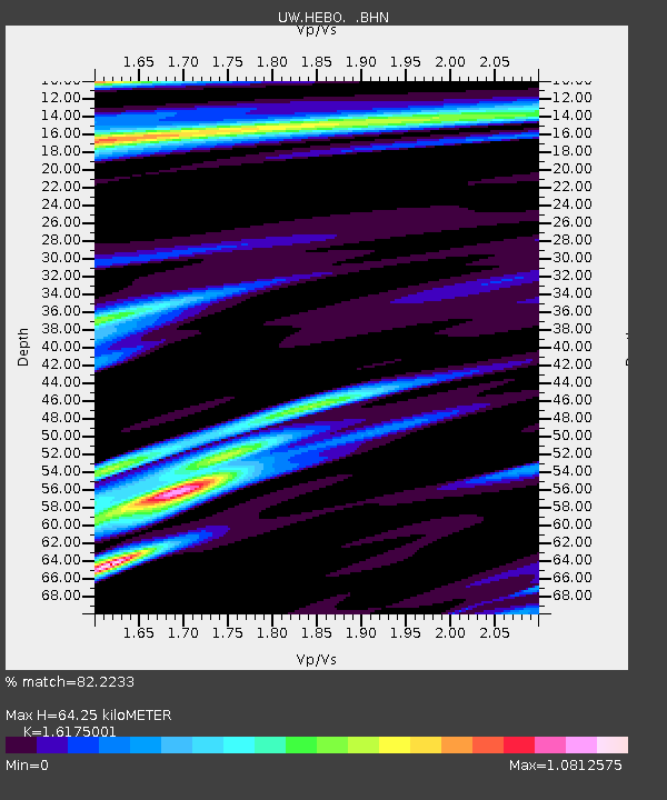
| Estimated Moho Depth: |
64.25 km |
| Estimated Crust Vp/Vs: |
1.62 |
| Assumed Crust Vp: |
6.566 km/s |
| Estimated Crust Vs: |
4.059 km/s |
| Estimated Crust Poisson's Ratio: |
0.19 |
|
| Radial Match: |
82.2233 % |
| Radial Bump: |
379 |
| Transverse Match: |
78.3728 % |
| Transverse Bump: |
400 |
| SOD ConfigId: |
2622 |
| Insert Time: |
2010-02-27 04:22:07.867 +0000 |
| GWidth: |
2.5 |
| Max Bumps: |
400 |
| Tol: |
0.001 |
|
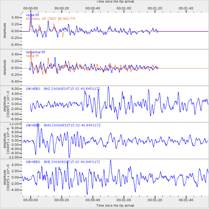
Signal To Noise
| Channel | StoN | STA | LTA |
| UW:HEBO: :BHN:20090830T15:02:40.845017Z | 8.21243 | 4.702642E-6 | 5.726249E-7 |
| UW:HEBO: :BHE:20090830T15:02:40.845017Z | 2.3663502 | 1.1210725E-6 | 4.7375596E-7 |
| UW:HEBO: :BHZ:20090830T15:02:40.845017Z | 1.6908094 | 1.3404363E-6 | 7.927778E-7 |
| Arrivals |
| Ps | 6.3 SECOND |
| PpPs | 25 SECOND |
| PsPs/PpSs | 31 SECOND |


