You are here: Home > Network List > UW - Pacific Northwest Regional Seismic Network Stations List
> Station HEBO Mt. Hebo, OR CREST BB SMO > Earthquake Result Viewer
HEBO Mt. Hebo, OR CREST BB SMO - Earthquake Result Viewer
| Earthquake location: |
Caribbean Sea |
| Earthquake latitude/longitude: |
19.0/-81.4 |
| Earthquake time(UTC): |
2004/12/14 (349) 23:20:13 GMT |
| Earthquake Depth: |
10 km |
| Earthquake Magnitude: |
6.2 MB, 6.7 MS, 6.8 MW, 6.8 MW |
| Earthquake Catalog/Contributor: |
WHDF/NEIC |
|
| Network: |
UW Pacific Northwest Regional Seismic Network |
| Station: |
HEBO Mt. Hebo, OR CREST BB SMO |
| Lat/Lon: |
45.21 N/123.75 W |
| Elevation: |
875 m |
|
| Distance: |
43.7 deg |
| Az: |
316.445 deg |
| Baz: |
112.69 deg |
| Ray Param: |
0.072376974 |
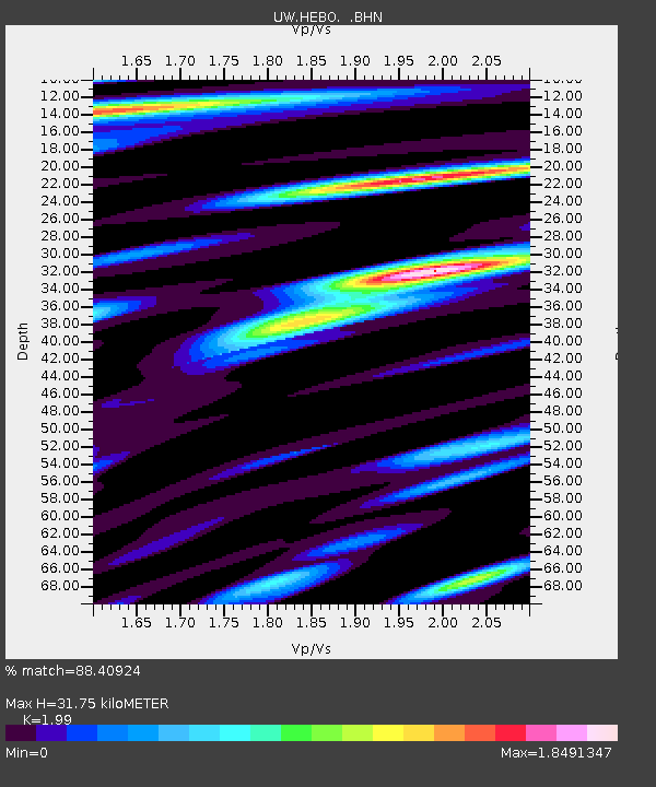
| Estimated Moho Depth: |
31.75 km |
| Estimated Crust Vp/Vs: |
1.99 |
| Assumed Crust Vp: |
6.566 km/s |
| Estimated Crust Vs: |
3.3 km/s |
| Estimated Crust Poisson's Ratio: |
0.33 |
|
| Radial Match: |
88.40924 % |
| Radial Bump: |
400 |
| Transverse Match: |
79.31999 % |
| Transverse Bump: |
400 |
| SOD ConfigId: |
2459 |
| Insert Time: |
2010-02-27 04:22:25.299 +0000 |
| GWidth: |
2.5 |
| Max Bumps: |
400 |
| Tol: |
0.001 |
|
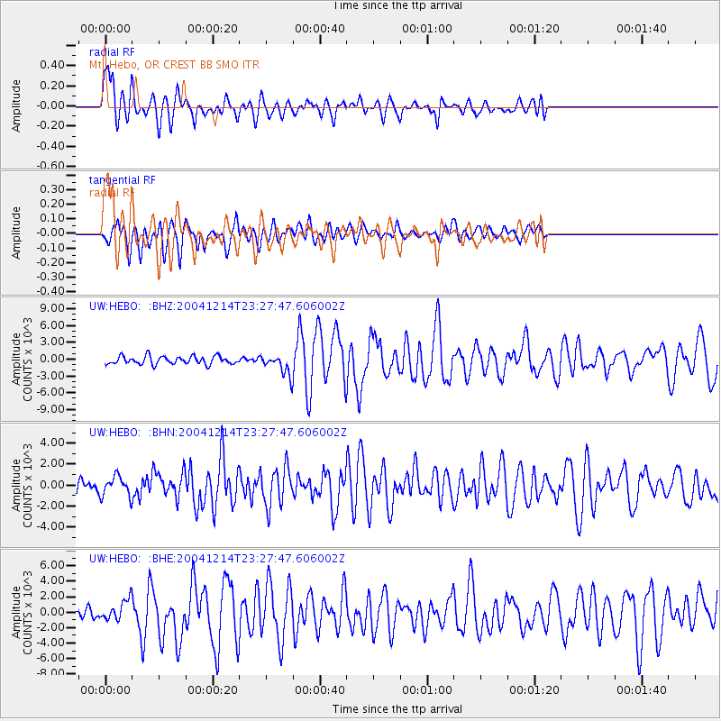
Signal To Noise
| Channel | StoN | STA | LTA |
| UW:HEBO: :BHN:20041214T23:27:47.606002Z | 1.2039633 | 940.23553 | 780.9503 |
| UW:HEBO: :BHE:20041214T23:27:47.606002Z | 1.147343 | 1252.9758 | 1092.0673 |
| UW:HEBO: :BHZ:20041214T23:27:47.606002Z | 2.4731183 | 1763.2427 | 712.9633 |
| Arrivals |
| Ps | 5.1 SECOND |
| PpPs | 14 SECOND |
| PsPs/PpSs | 19 SECOND |


