You are here: Home > Network List > 1U - Mt. Paektu Seismic Network Stations List
> Station PSRD Paek San Ri > Earthquake Result Viewer
PSRD Paek San Ri - Earthquake Result Viewer
| Earthquake location: |
Iran-Iraq Border Region |
| Earthquake latitude/longitude: |
32.7/47.7 |
| Earthquake time(UTC): |
2014/08/18 (230) 02:32:05 GMT |
| Earthquake Depth: |
10 km |
| Earthquake Magnitude: |
6.2 MWP |
| Earthquake Catalog/Contributor: |
NEIC PDE/NEIC COMCAT |
|
| Network: |
1U Mt. Paektu Seismic Network |
| Station: |
PSRD Paek San Ri |
| Lat/Lon: |
41.94 N/128.62 E |
| Elevation: |
1101 m |
|
| Distance: |
62.8 deg |
| Az: |
55.945 deg |
| Baz: |
290.63 deg |
| Ray Param: |
0.059997257 |
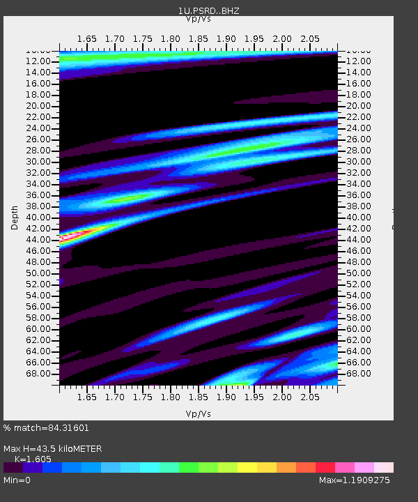
| Estimated Moho Depth: |
43.5 km |
| Estimated Crust Vp/Vs: |
1.61 |
| Assumed Crust Vp: |
6.472 km/s |
| Estimated Crust Vs: |
4.032 km/s |
| Estimated Crust Poisson's Ratio: |
0.18 |
|
| Radial Match: |
84.31601 % |
| Radial Bump: |
400 |
| Transverse Match: |
55.666 % |
| Transverse Bump: |
400 |
| SOD ConfigId: |
3390531 |
| Insert Time: |
2019-04-13 10:10:06.877 +0000 |
| GWidth: |
2.5 |
| Max Bumps: |
400 |
| Tol: |
0.001 |
|

Signal To Noise
| Channel | StoN | STA | LTA |
| 1U:PSRD: :BHZ:20140818T02:41:58.73998Z | 16.357756 | 8.0852357E-7 | 4.9427534E-8 |
| 1U:PSRD: :BHN:20140818T02:41:58.73998Z | 3.7023702 | 2.6860613E-7 | 7.254978E-8 |
| 1U:PSRD: :BHE:20140818T02:41:58.73998Z | 3.384084 | 3.6572897E-7 | 1.0807325E-7 |
| Arrivals |
| Ps | 4.3 SECOND |
| PpPs | 17 SECOND |
| PsPs/PpSs | 21 SECOND |


