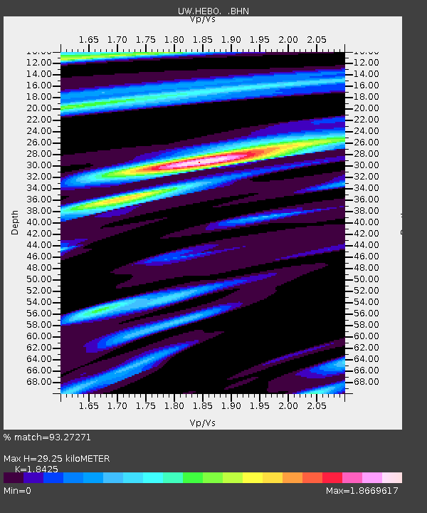
HEBO Mt. Hebo, OR CREST BB SMO - Earthquake Result Viewer

Earthquake location: Near S. Coast Of Honshu, Japan
Earthquake latitude/longitude: 33.1/137.2
Earthquake time(UTC): 2004/09/08 (252) 14:58:25 GMT
Earthquake Depth: 21 km
Earthquake Magnitude: 6.2 MB, 5.8 MS, 6.2 MW, 6.1 MW
Earthquake Catalog/Contributor: WHDF/NEIC
Network: UW Pacific Northwest Regional Seismic Network
Station: HEBO Mt. Hebo, OR CREST BB SMO
Lat/Lon: 45.21 N/123.75 W
Elevation: 875 m
Distance: 73.0 deg
Az: 46.868 deg
Baz: 299.976 deg
Ray Param: 0.053241394
Estimated Moho Depth: 29.25 km
Estimated Crust Vp/Vs: 1.84
Assumed Crust Vp: 6.566 km/s
Estimated Crust Vs: 3.564 km/s
Estimated Crust Poisson's Ratio: 0.29
Radial Match: 93.27271 %
Radial Bump: 400
Transverse Match: 70.4873 %
Transverse Bump: 400
SOD ConfigId: 2459
Insert Time: 2010-02-27 04:22:26.847 +0000
GWidth: 2.5
Max Bumps: 400
Tol: 0.001

Signal To Noise

ChannelStoNSTALTA
UW:HEBO: :BHN:20040908T15:09:22.905012Z2.2070816225.51904102.17975
UW:HEBO: :BHE:20040908T15:09:22.905012Z3.9083474403.61218103.26927
UW:HEBO: :BHZ:20040908T15:09:22.905012Z18.2708451280.489470.08375
Arrivals
Ps3.9 SECOND
PpPs12 SECOND
PsPs/PpSs16 SECOND