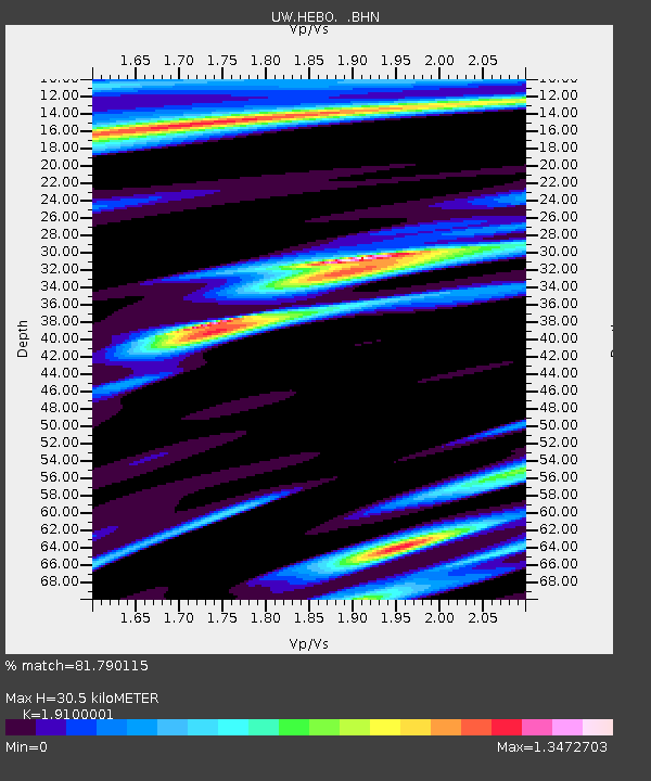
HEBO Mt. Hebo, OR CREST BB SMO - Earthquake Result Viewer

Earthquake location: Santiago Del Estero Prov., Arg.
Earthquake latitude/longitude: -28.6/-65.8
Earthquake time(UTC): 2004/09/07 (251) 11:53:06 GMT
Earthquake Depth: 22 km
Earthquake Magnitude: 6.1 MB, 6.1 MS, 6.4 MW, 6.2 MW
Earthquake Catalog/Contributor: WHDF/NEIC
Network: UW Pacific Northwest Regional Seismic Network
Station: HEBO Mt. Hebo, OR CREST BB SMO
Lat/Lon: 45.21 N/123.75 W
Elevation: 875 m
Distance: 90.4 deg
Az: 323.21 deg
Baz: 131.822 deg
Ray Param: 0.041676745
Estimated Moho Depth: 30.5 km
Estimated Crust Vp/Vs: 1.91
Assumed Crust Vp: 6.566 km/s
Estimated Crust Vs: 3.438 km/s
Estimated Crust Poisson's Ratio: 0.31
Radial Match: 81.790115 %
Radial Bump: 400
Transverse Match: 68.979416 %
Transverse Bump: 400
SOD ConfigId: 2459
Insert Time: 2010-02-27 04:22:28.372 +0000
GWidth: 2.5
Max Bumps: 400
Tol: 0.001

Signal To Noise

ChannelStoNSTALTA
UW:HEBO: :BHN:20040907T12:05:33.945022Z1.4303244243.45053170.20651
UW:HEBO: :BHE:20040907T12:05:33.945022Z1.2696368304.79898240.06789
UW:HEBO: :BHZ:20040907T12:05:33.945022Z6.24162151388.1052222.39497
Arrivals
Ps4.3 SECOND
PpPs13 SECOND
PsPs/PpSs18 SECOND