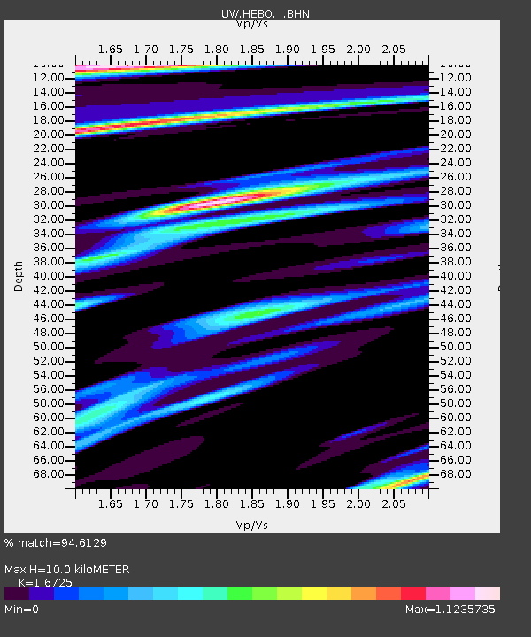
HEBO Mt. Hebo, OR CREST BB SMO - Earthquake Result Viewer

Earthquake location: Near S. Coast Of Western Honshu
Earthquake latitude/longitude: 33.1/136.6
Earthquake time(UTC): 2004/09/05 (249) 10:07:07 GMT
Earthquake Depth: 14 km
Earthquake Magnitude: 6.7 MB, 7.0 MS, 7.2 MW, 7.0 MW
Earthquake Catalog/Contributor: WHDF/NEIC
Network: UW Pacific Northwest Regional Seismic Network
Station: HEBO Mt. Hebo, OR CREST BB SMO
Lat/Lon: 45.21 N/123.75 W
Elevation: 875 m
Distance: 73.4 deg
Az: 46.637 deg
Baz: 300.272 deg
Ray Param: 0.05299017
Estimated Moho Depth: 10.0 km
Estimated Crust Vp/Vs: 1.67
Assumed Crust Vp: 6.566 km/s
Estimated Crust Vs: 3.926 km/s
Estimated Crust Poisson's Ratio: 0.22
Radial Match: 94.6129 %
Radial Bump: 400
Transverse Match: 83.50053 %
Transverse Bump: 400
SOD ConfigId: 2459
Insert Time: 2010-02-27 04:22:30.280 +0000
GWidth: 2.5
Max Bumps: 400
Tol: 0.001

Signal To Noise

ChannelStoNSTALTA
UW:HEBO: :BHN:20040905T10:18:08.286003Z3.6881441287.5181349.09647
UW:HEBO: :BHE:20040905T10:18:08.286003Z7.71191262313.0417299.931
UW:HEBO: :BHZ:20040905T10:18:08.286003Z27.9927985778.0435206.41177
Arrivals
Ps1.1 SECOND
PpPs3.9 SECOND
PsPs/PpSs5.0 SECOND