You are here: Home > Network List > TA - USArray Transportable Network (new EarthScope stations) Stations List
> Station O48A Farmland, IN, USA > Earthquake Result Viewer
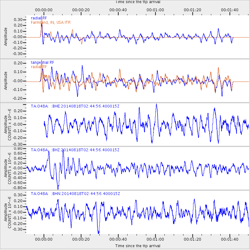
O48A Farmland, IN, USA - Earthquake Result Viewer
*The percent match for this event was below the threshold and hence no stack was calculated.
| Earthquake location: |
Iran-Iraq Border Region |
| Earthquake latitude/longitude: |
32.7/47.7 |
| Earthquake time(UTC): |
2014/08/18 (230) 02:32:05 GMT |
| Earthquake Depth: |
10 km |
| Earthquake Magnitude: |
6.2 MWP |
| Earthquake Catalog/Contributor: |
NEIC PDE/NEIC COMCAT |
|
| Network: |
TA USArray Transportable Network (new EarthScope stations) |
| Station: |
O48A Farmland, IN, USA |
| Lat/Lon: |
40.26 N/85.16 W |
| Elevation: |
300 m |
|
| Distance: |
95.3 deg |
| Az: |
325.69 deg |
| Baz: |
38.372 deg |
| Ray Param: |
$rayparam |
*The percent match for this event was below the threshold and hence was not used in the summary stack. |
|
| Radial Match: |
65.216225 % |
| Radial Bump: |
363 |
| Transverse Match: |
63.760292 % |
| Transverse Bump: |
341 |
| SOD ConfigId: |
3390531 |
| Insert Time: |
2019-04-13 10:13:15.276 +0000 |
| GWidth: |
2.5 |
| Max Bumps: |
400 |
| Tol: |
0.001 |
|
Signal To Noise
| Channel | StoN | STA | LTA |
| TA:O48A: :BHZ:20140818T02:44:56.400015Z | 4.1988063 | 3.0721E-7 | 7.316603E-8 |
| TA:O48A: :BHN:20140818T02:44:56.400015Z | 0.8057088 | 5.1577715E-8 | 6.401533E-8 |
| TA:O48A: :BHE:20140818T02:44:56.400015Z | 1.2519734 | 9.737947E-8 | 7.778079E-8 |
| Arrivals |
| Ps | |
| PpPs | |
| PsPs/PpSs | |


