You are here: Home > Network List > X812 - Deep Structure of Three Continental Sutures in Eastern North America Stations List
> Station QM20 Hay Lake, Maine, USA > Earthquake Result Viewer
QM20 Hay Lake, Maine, USA - Earthquake Result Viewer

| Earthquake location: |
Iran-Iraq Border Region |
| Earthquake latitude/longitude: |
32.7/47.7 |
| Earthquake time(UTC): |
2014/08/18 (230) 02:32:05 GMT |
| Earthquake Depth: |
10 km |
| Earthquake Magnitude: |
6.2 MWP |
| Earthquake Catalog/Contributor: |
NEIC PDE/NEIC COMCAT |
|
| Network: |
X8 Deep Structure of Three Continental Sutures in Eastern North America |
| Station: |
QM20 Hay Lake, Maine, USA |
| Lat/Lon: |
46.13 N/68.72 W |
| Elevation: |
207 m |
|
| Distance: |
82.7 deg |
| Az: |
321.096 deg |
| Baz: |
49.557 deg |
| Ray Param: |
0.046672378 |
| Estimated Moho Depth: |
32.0 km |
| Estimated Crust Vp/Vs: |
1.73 |
| Assumed Crust Vp: |
6.419 km/s |
| Estimated Crust Vs: |
3.721 km/s |
| Estimated Crust Poisson's Ratio: |
0.25 |
|
| Radial Match: |
80.11892 % |
| Radial Bump: |
340 |
| Transverse Match: |
58.36427 % |
| Transverse Bump: |
393 |
| SOD ConfigId: |
3390531 |
| Insert Time: |
2019-04-13 10:13:50.595 +0000 |
| GWidth: |
2.5 |
| Max Bumps: |
400 |
| Tol: |
0.001 |
|
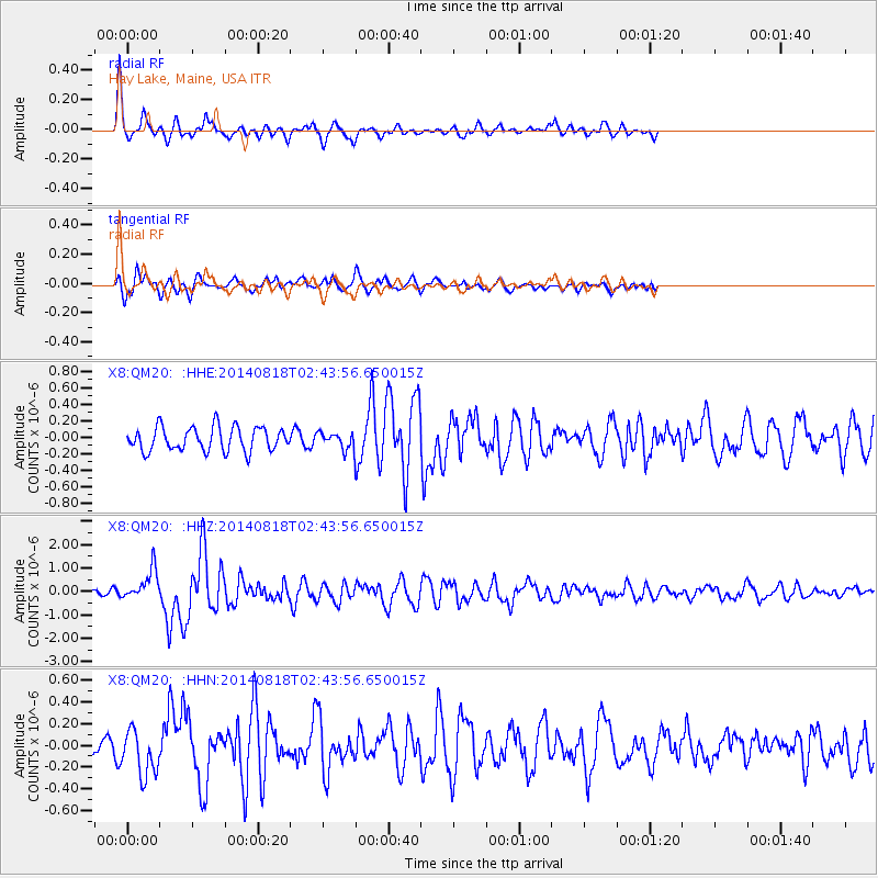
Signal To Noise
| Channel | StoN | STA | LTA |
| X8:QM20: :HHZ:20140818T02:43:56.650015Z | 5.0509295 | 6.5428907E-7 | 1.2953834E-7 |
| X8:QM20: :HHN:20140818T02:43:56.650015Z | 1.571459 | 2.0986234E-7 | 1.3354617E-7 |
| X8:QM20: :HHE:20140818T02:43:56.650015Z | 1.2567502 | 1.8447912E-7 | 1.4679058E-7 |
| Arrivals |
| Ps | 3.7 SECOND |
| PpPs | 13 SECOND |
| PsPs/PpSs | 17 SECOND |


