You are here: Home > Network List > II - Global Seismograph Network (GSN - IRIS/IDA) Stations List
> Station WRAB Tennant Creek, NT, Australia > Earthquake Result Viewer
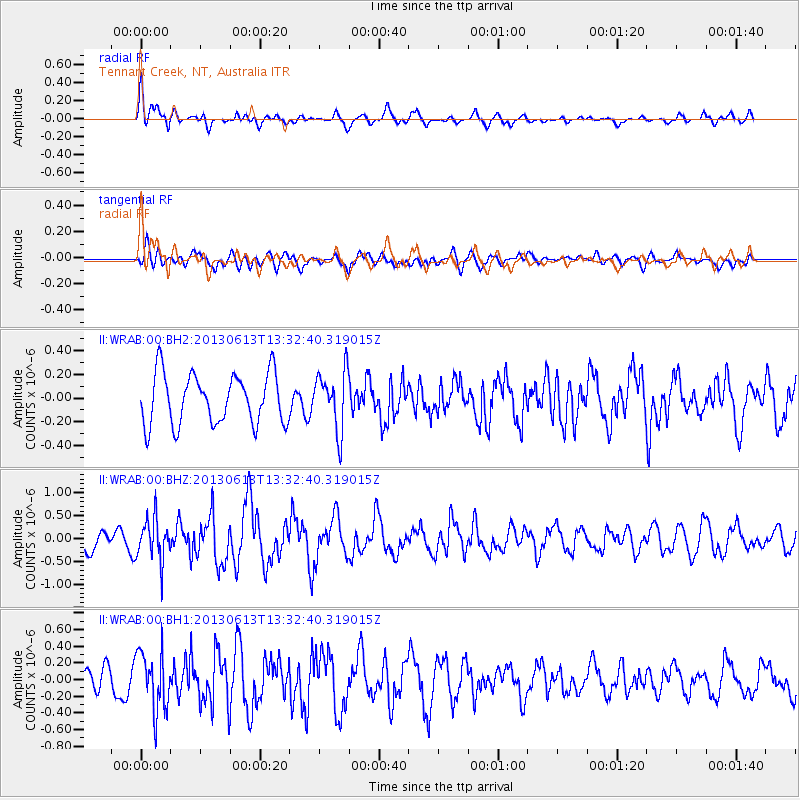
WRAB Tennant Creek, NT, Australia - Earthquake Result Viewer
*The percent match for this event was below the threshold and hence no stack was calculated.
| Earthquake location: |
Ryukyu Islands, Japan |
| Earthquake latitude/longitude: |
26.5/128.9 |
| Earthquake time(UTC): |
2013/06/13 (164) 13:24:45 GMT |
| Earthquake Depth: |
20 km |
| Earthquake Magnitude: |
5.6 MW, 5.6 MW, 5.9 MB |
| Earthquake Catalog/Contributor: |
NEIC PDE/NEIC PDE-W |
|
| Network: |
II Global Seismograph Network (GSN - IRIS/IDA) |
| Station: |
WRAB Tennant Creek, NT, Australia |
| Lat/Lon: |
19.93 S/134.36 E |
| Elevation: |
366 m |
|
| Distance: |
46.5 deg |
| Az: |
172.892 deg |
| Baz: |
353.233 deg |
| Ray Param: |
$rayparam |
*The percent match for this event was below the threshold and hence was not used in the summary stack. |
|
| Radial Match: |
70.299164 % |
| Radial Bump: |
400 |
| Transverse Match: |
55.795704 % |
| Transverse Bump: |
400 |
| SOD ConfigId: |
512894 |
| Insert Time: |
2013-09-15 03:05:12.626 +0000 |
| GWidth: |
2.5 |
| Max Bumps: |
400 |
| Tol: |
0.001 |
|
Signal To Noise
| Channel | StoN | STA | LTA |
| II:WRAB:00:BHZ:20130613T13:32:40.319015Z | 1.9338436 | 4.5785592E-7 | 2.3675953E-7 |
| II:WRAB:00:BH1:20130613T13:32:40.319015Z | 2.652966 | 3.561953E-7 | 1.3426305E-7 |
| II:WRAB:00:BH2:20130613T13:32:40.319015Z | 1.1777197 | 2.5058202E-7 | 2.1276881E-7 |
| Arrivals |
| Ps | |
| PpPs | |
| PsPs/PpSs | |


