You are here: Home > Network List > IU - Global Seismograph Network (GSN - IRIS/USGS) Stations List
> Station KBL Kabul, Afghanistan > Earthquake Result Viewer
KBL Kabul, Afghanistan - Earthquake Result Viewer
| Earthquake location: |
Ryukyu Islands, Japan |
| Earthquake latitude/longitude: |
26.5/128.9 |
| Earthquake time(UTC): |
2013/06/13 (164) 13:24:45 GMT |
| Earthquake Depth: |
20 km |
| Earthquake Magnitude: |
5.6 MW, 5.6 MW, 5.9 MB |
| Earthquake Catalog/Contributor: |
NEIC PDE/NEIC PDE-W |
|
| Network: |
IU Global Seismograph Network (GSN - IRIS/USGS) |
| Station: |
KBL Kabul, Afghanistan |
| Lat/Lon: |
34.54 N/69.04 E |
| Elevation: |
1920 m |
|
| Distance: |
51.5 deg |
| Az: |
294.24 deg |
| Baz: |
81.718 deg |
| Ray Param: |
0.0673394 |
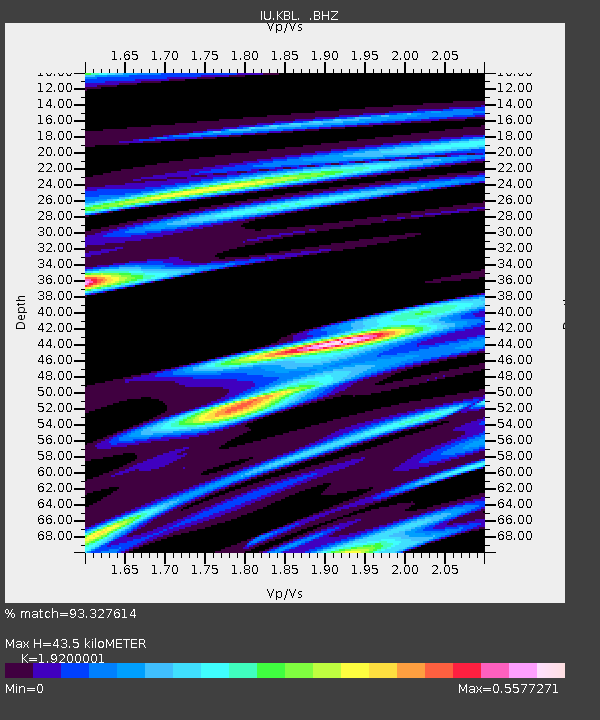
| Estimated Moho Depth: |
43.5 km |
| Estimated Crust Vp/Vs: |
1.92 |
| Assumed Crust Vp: |
6.641 km/s |
| Estimated Crust Vs: |
3.459 km/s |
| Estimated Crust Poisson's Ratio: |
0.31 |
|
| Radial Match: |
93.327614 % |
| Radial Bump: |
400 |
| Transverse Match: |
90.43378 % |
| Transverse Bump: |
400 |
| SOD ConfigId: |
512894 |
| Insert Time: |
2013-09-15 03:06:10.176 +0000 |
| GWidth: |
2.5 |
| Max Bumps: |
400 |
| Tol: |
0.001 |
|
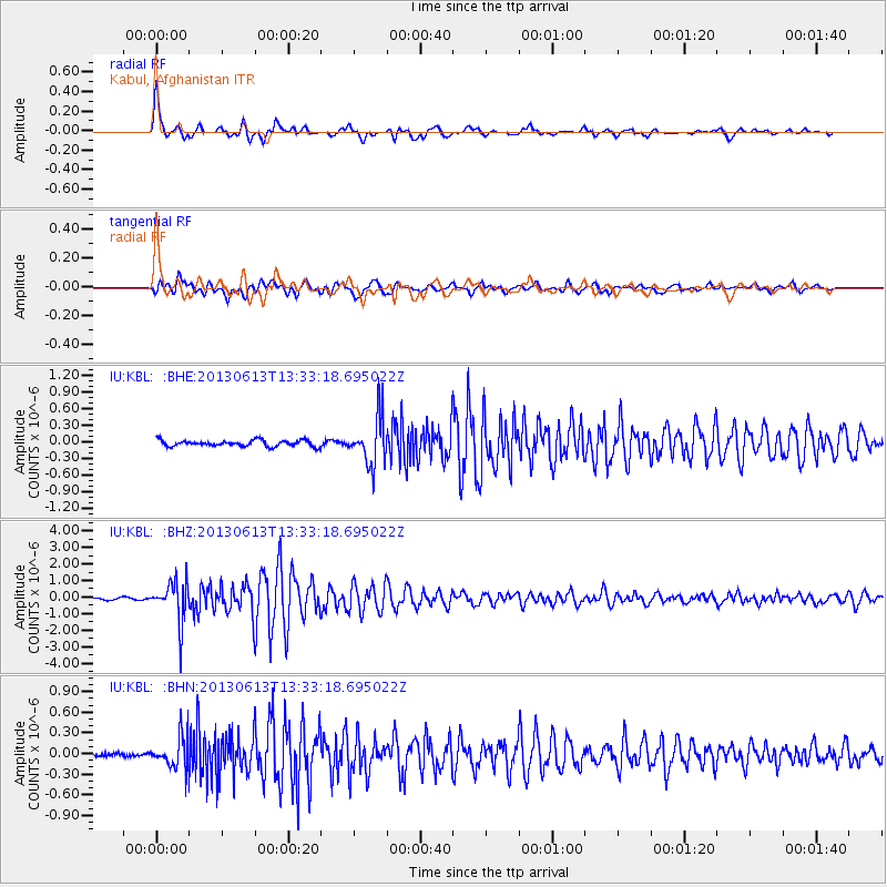
Signal To Noise
| Channel | StoN | STA | LTA |
| IU:KBL: :BHZ:20130613T13:33:18.695022Z | 19.955336 | 1.1803239E-6 | 5.9148284E-8 |
| IU:KBL: :BHN:20130613T13:33:18.695022Z | 6.7459106 | 2.2580504E-7 | 3.3472876E-8 |
| IU:KBL: :BHE:20130613T13:33:18.695022Z | 7.7349854 | 4.2921656E-7 | 5.5490286E-8 |
| Arrivals |
| Ps | 6.4 SECOND |
| PpPs | 18 SECOND |
| PsPs/PpSs | 24 SECOND |


