You are here: Home > Network List > XL12 - Hangay Dome, Mongolia Stations List
> Station AT13 AT13 > Earthquake Result Viewer
AT13 AT13 - Earthquake Result Viewer
| Earthquake location: |
Iran-Iraq Border Region |
| Earthquake latitude/longitude: |
32.7/47.7 |
| Earthquake time(UTC): |
2014/08/18 (230) 02:32:05 GMT |
| Earthquake Depth: |
10 km |
| Earthquake Magnitude: |
6.2 MWP |
| Earthquake Catalog/Contributor: |
NEIC PDE/NEIC COMCAT |
|
| Network: |
XL Hangay Dome, Mongolia |
| Station: |
AT13 AT13 |
| Lat/Lon: |
44.99 N/96.27 E |
| Elevation: |
1091 m |
|
| Distance: |
39.2 deg |
| Az: |
57.332 deg |
| Baz: |
269.022 deg |
| Ray Param: |
0.07511098 |
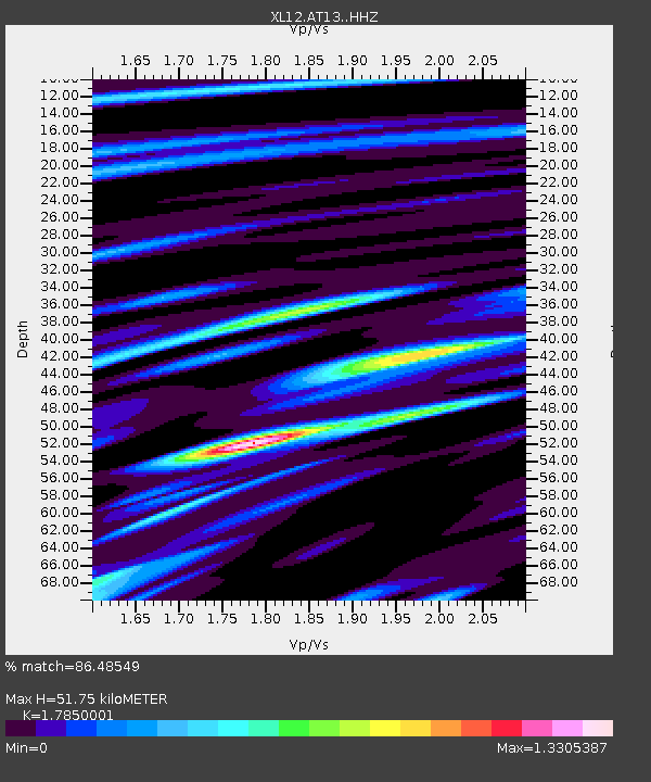
| Estimated Moho Depth: |
51.75 km |
| Estimated Crust Vp/Vs: |
1.79 |
| Assumed Crust Vp: |
6.353 km/s |
| Estimated Crust Vs: |
3.559 km/s |
| Estimated Crust Poisson's Ratio: |
0.27 |
|
| Radial Match: |
86.48549 % |
| Radial Bump: |
400 |
| Transverse Match: |
69.96141 % |
| Transverse Bump: |
400 |
| SOD ConfigId: |
3390531 |
| Insert Time: |
2019-04-13 10:14:29.782 +0000 |
| GWidth: |
2.5 |
| Max Bumps: |
400 |
| Tol: |
0.001 |
|

Signal To Noise
| Channel | StoN | STA | LTA |
| XL:AT13: :HHZ:20140818T02:39:01.869985Z | 63.404453 | 1.3974906E-6 | 2.2040892E-8 |
| XL:AT13: :HHN:20140818T02:39:01.869985Z | 5.3847604 | 1.8634819E-7 | 3.460659E-8 |
| XL:AT13: :HHE:20140818T02:39:01.869985Z | 29.148247 | 9.4917726E-7 | 3.2563786E-8 |
| Arrivals |
| Ps | 6.9 SECOND |
| PpPs | 21 SECOND |
| PsPs/PpSs | 28 SECOND |


