You are here: Home > Network List > XL12 - Hangay Dome, Mongolia Stations List
> Station HV26 HV26 > Earthquake Result Viewer
HV26 HV26 - Earthquake Result Viewer
| Earthquake location: |
Iran-Iraq Border Region |
| Earthquake latitude/longitude: |
32.7/47.7 |
| Earthquake time(UTC): |
2014/08/18 (230) 02:32:05 GMT |
| Earthquake Depth: |
10 km |
| Earthquake Magnitude: |
6.2 MWP |
| Earthquake Catalog/Contributor: |
NEIC PDE/NEIC COMCAT |
|
| Network: |
XL Hangay Dome, Mongolia |
| Station: |
HV26 HV26 |
| Lat/Lon: |
50.62 N/101.86 E |
| Elevation: |
1158 m |
|
| Distance: |
43.2 deg |
| Az: |
48.995 deg |
| Baz: |
266.875 deg |
| Ray Param: |
0.07270905 |
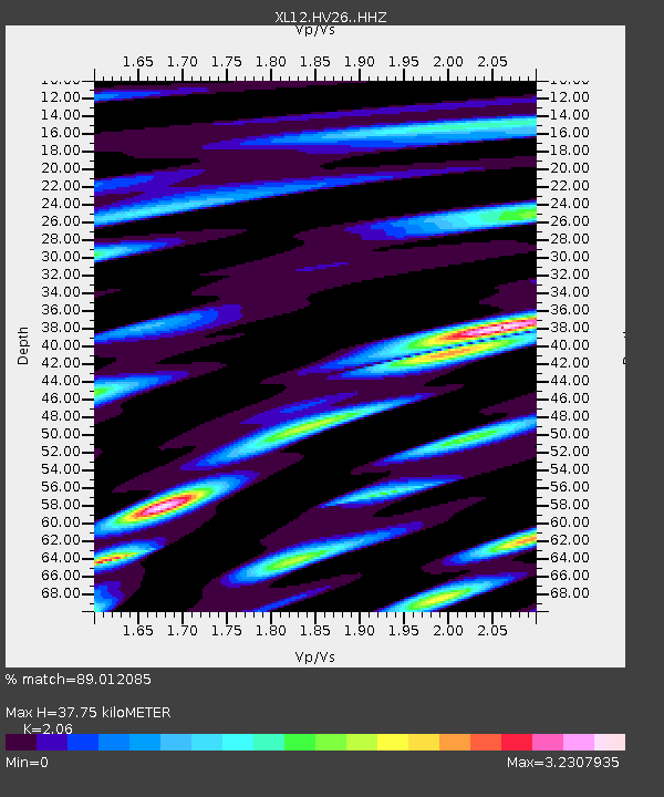
| Estimated Moho Depth: |
37.75 km |
| Estimated Crust Vp/Vs: |
2.06 |
| Assumed Crust Vp: |
6.419 km/s |
| Estimated Crust Vs: |
3.116 km/s |
| Estimated Crust Poisson's Ratio: |
0.35 |
|
| Radial Match: |
89.012085 % |
| Radial Bump: |
400 |
| Transverse Match: |
78.457825 % |
| Transverse Bump: |
400 |
| SOD ConfigId: |
3390531 |
| Insert Time: |
2019-04-13 10:14:42.499 +0000 |
| GWidth: |
2.5 |
| Max Bumps: |
400 |
| Tol: |
0.001 |
|

Signal To Noise
| Channel | StoN | STA | LTA |
| XL:HV26: :HHZ:20140818T02:39:34.508993Z | 29.144297 | 1.2885678E-6 | 4.4213376E-8 |
| XL:HV26: :HHN:20140818T02:39:34.508993Z | 1.6883976 | 7.392169E-8 | 4.378216E-8 |
| XL:HV26: :HHE:20140818T02:39:34.508993Z | 6.822792 | 3.4554006E-7 | 5.0644964E-8 |
| Arrivals |
| Ps | 6.6 SECOND |
| PpPs | 17 SECOND |
| PsPs/PpSs | 24 SECOND |


