You are here: Home > Network List > TA - USArray Transportable Network (new EarthScope stations) Stations List
> Station D03D Eldon, WA, USA > Earthquake Result Viewer
D03D Eldon, WA, USA - Earthquake Result Viewer
| Earthquake location: |
Ryukyu Islands, Japan |
| Earthquake latitude/longitude: |
26.5/128.9 |
| Earthquake time(UTC): |
2013/06/13 (164) 13:24:45 GMT |
| Earthquake Depth: |
20 km |
| Earthquake Magnitude: |
5.6 MW, 5.6 MW, 5.9 MB |
| Earthquake Catalog/Contributor: |
NEIC PDE/NEIC PDE-W |
|
| Network: |
TA USArray Transportable Network (new EarthScope stations) |
| Station: |
D03D Eldon, WA, USA |
| Lat/Lon: |
47.53 N/123.09 W |
| Elevation: |
262 m |
|
| Distance: |
82.0 deg |
| Az: |
40.592 deg |
| Baz: |
300.656 deg |
| Ray Param: |
0.04716344 |
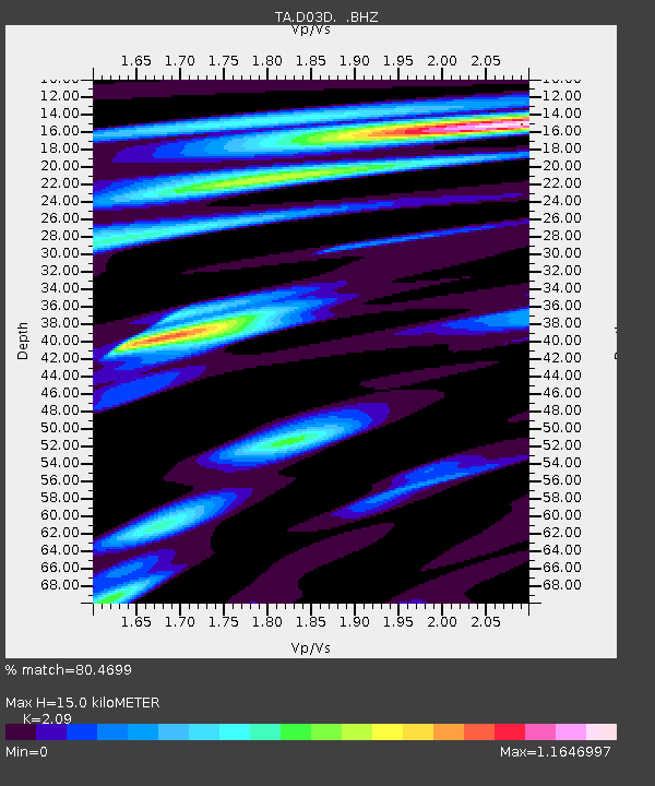
| Estimated Moho Depth: |
15.0 km |
| Estimated Crust Vp/Vs: |
2.09 |
| Assumed Crust Vp: |
6.566 km/s |
| Estimated Crust Vs: |
3.142 km/s |
| Estimated Crust Poisson's Ratio: |
0.35 |
|
| Radial Match: |
80.4699 % |
| Radial Bump: |
400 |
| Transverse Match: |
71.79609 % |
| Transverse Bump: |
400 |
| SOD ConfigId: |
512894 |
| Insert Time: |
2013-09-15 03:12:35.766 +0000 |
| GWidth: |
2.5 |
| Max Bumps: |
400 |
| Tol: |
0.001 |
|

Signal To Noise
| Channel | StoN | STA | LTA |
| TA:D03D: :BHZ:20130613T13:36:32.550002Z | 7.8529353 | 5.869882E-7 | 7.474762E-8 |
| TA:D03D: :BHN:20130613T13:36:32.550002Z | 2.6574626 | 1.3123625E-7 | 4.9384045E-8 |
| TA:D03D: :BHE:20130613T13:36:32.550002Z | 1.1532372 | 1.4664103E-7 | 1.27156E-7 |
| Arrivals |
| Ps | 2.5 SECOND |
| PpPs | 6.9 SECOND |
| PsPs/PpSs | 9.4 SECOND |


