You are here: Home > Network List > TA - USArray Transportable Network (new EarthScope stations) Stations List
> Station O03E Paynes Creek, CA, USA > Earthquake Result Viewer
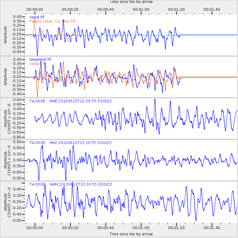
O03E Paynes Creek, CA, USA - Earthquake Result Viewer
*The percent match for this event was below the threshold and hence no stack was calculated.
| Earthquake location: |
Ryukyu Islands, Japan |
| Earthquake latitude/longitude: |
26.5/128.9 |
| Earthquake time(UTC): |
2013/06/13 (164) 13:24:45 GMT |
| Earthquake Depth: |
20 km |
| Earthquake Magnitude: |
5.6 MW, 5.6 MW, 5.9 MB |
| Earthquake Catalog/Contributor: |
NEIC PDE/NEIC PDE-W |
|
| Network: |
TA USArray Transportable Network (new EarthScope stations) |
| Station: |
O03E Paynes Creek, CA, USA |
| Lat/Lon: |
40.29 N/121.80 W |
| Elevation: |
967 m |
|
| Distance: |
86.6 deg |
| Az: |
46.312 deg |
| Baz: |
302.117 deg |
| Ray Param: |
$rayparam |
*The percent match for this event was below the threshold and hence was not used in the summary stack. |
|
| Radial Match: |
61.554043 % |
| Radial Bump: |
388 |
| Transverse Match: |
67.49621 % |
| Transverse Bump: |
332 |
| SOD ConfigId: |
512894 |
| Insert Time: |
2013-09-15 03:14:01.027 +0000 |
| GWidth: |
2.5 |
| Max Bumps: |
400 |
| Tol: |
0.001 |
|
Signal To Noise
| Channel | StoN | STA | LTA |
| TA:O03E: :HHZ:20130613T13:36:55.63002Z | 5.494302 | 4.233596E-7 | 7.705431E-8 |
| TA:O03E: :HHN:20130613T13:36:55.63002Z | 2.2850158 | 2.076874E-7 | 9.0891014E-8 |
| TA:O03E: :HHE:20130613T13:36:55.63002Z | 0.8938784 | 1.3995844E-7 | 1.5657436E-7 |
| Arrivals |
| Ps | |
| PpPs | |
| PsPs/PpSs | |


