You are here: Home > Network List > TJ - Tajikistan National Seismic Network Stations List
> Station SHAA Shaartuz, Tajikistan > Earthquake Result Viewer
SHAA Shaartuz, Tajikistan - Earthquake Result Viewer
| Earthquake location: |
Ryukyu Islands, Japan |
| Earthquake latitude/longitude: |
26.5/128.9 |
| Earthquake time(UTC): |
2013/06/13 (164) 13:24:45 GMT |
| Earthquake Depth: |
20 km |
| Earthquake Magnitude: |
5.6 MW, 5.6 MW, 5.9 MB |
| Earthquake Catalog/Contributor: |
NEIC PDE/NEIC PDE-W |
|
| Network: |
TJ Tajikistan National Seismic Network |
| Station: |
SHAA Shaartuz, Tajikistan |
| Lat/Lon: |
37.56 N/68.12 E |
| Elevation: |
868 m |
|
| Distance: |
51.9 deg |
| Az: |
298.172 deg |
| Baz: |
83.616 deg |
| Ray Param: |
0.06710333 |
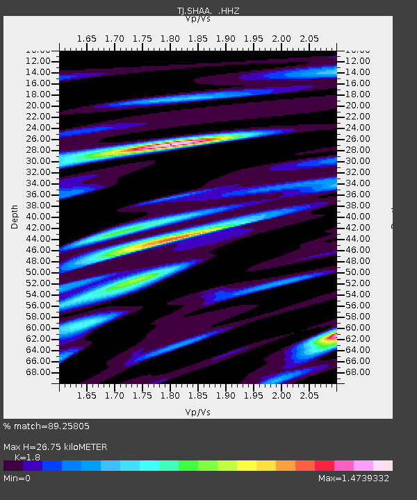
| Estimated Moho Depth: |
26.75 km |
| Estimated Crust Vp/Vs: |
1.80 |
| Assumed Crust Vp: |
6.213 km/s |
| Estimated Crust Vs: |
3.452 km/s |
| Estimated Crust Poisson's Ratio: |
0.28 |
|
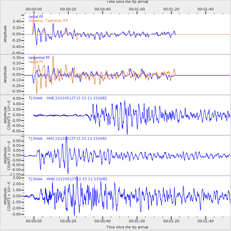
| Radial Match: |
89.25805 % |
| Radial Bump: |
400 |
| Transverse Match: |
83.17167 % |
| Transverse Bump: |
381 |
| SOD ConfigId: |
512894 |
| Insert Time: |
2013-09-15 03:14:19.486 +0000 |
| GWidth: |
2.5 |
| Max Bumps: |
400 |
| Tol: |
0.001 |
|
Signal To Noise
| Channel | StoN | STA | LTA |
| TJ:SHAA: :HHZ:20130613T13:33:21.33998Z | 13.394969 | 2.7598528E-6 | 2.0603652E-7 |
| TJ:SHAA: :HHN:20130613T13:33:21.33998Z | 2.8508425 | 5.1231984E-7 | 1.7970822E-7 |
| TJ:SHAA: :HHE:20130613T13:33:21.33998Z | 9.914624 | 1.3553691E-6 | 1.3670403E-7 |
| Arrivals |
| Ps | 3.6 SECOND |
| PpPs | 11 SECOND |
| PsPs/PpSs | 15 SECOND |


