You are here: Home > Network List > UW - Pacific Northwest Regional Seismic Network Stations List
> Station HEBO Mt. Hebo, OR CREST BB SMO > Earthquake Result Viewer
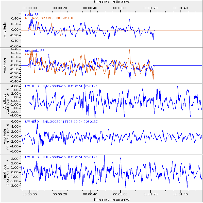
HEBO Mt. Hebo, OR CREST BB SMO - Earthquake Result Viewer
*The percent match for this event was below the threshold and hence no stack was calculated.
| Earthquake location: |
Near Coast Of Guatemala |
| Earthquake latitude/longitude: |
13.6/-90.6 |
| Earthquake time(UTC): |
2008/04/15 (106) 03:03:04 GMT |
| Earthquake Depth: |
33 km |
| Earthquake Magnitude: |
5.6 MB, 5.8 MS, 6.1 MW, 6.1 MW |
| Earthquake Catalog/Contributor: |
WHDF/NEIC |
|
| Network: |
UW Pacific Northwest Regional Seismic Network |
| Station: |
HEBO Mt. Hebo, OR CREST BB SMO |
| Lat/Lon: |
45.21 N/123.76 W |
| Elevation: |
875 m |
|
| Distance: |
42.2 deg |
| Az: |
324.896 deg |
| Baz: |
127.706 deg |
| Ray Param: |
$rayparam |
*The percent match for this event was below the threshold and hence was not used in the summary stack. |
|
| Radial Match: |
57.992935 % |
| Radial Bump: |
400 |
| Transverse Match: |
52.69188 % |
| Transverse Bump: |
400 |
| SOD ConfigId: |
2504 |
| Insert Time: |
2010-02-27 04:23:19.306 +0000 |
| GWidth: |
2.5 |
| Max Bumps: |
400 |
| Tol: |
0.001 |
|
Signal To Noise
| Channel | StoN | STA | LTA |
| UW:HEBO: :BHN:20080415T03:10:24.205013Z | 2.59431 | 2.4942938E-6 | 9.614479E-7 |
| UW:HEBO: :BHE:20080415T03:10:24.205013Z | 0.80802417 | 9.931456E-7 | 1.2291038E-6 |
| UW:HEBO: :BHZ:20080415T03:10:24.205013Z | 0.8001607 | 1.1427791E-6 | 1.4281869E-6 |
| Arrivals |
| Ps | |
| PpPs | |
| PsPs/PpSs | |


