You are here: Home > Network List > UW - Pacific Northwest Regional Seismic Network Stations List
> Station HOOD Mt Hood Meadows, OR CREST BB SMO > Earthquake Result Viewer
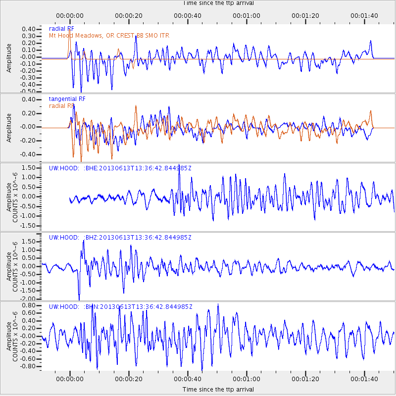
HOOD Mt Hood Meadows, OR CREST BB SMO - Earthquake Result Viewer
*The percent match for this event was below the threshold and hence no stack was calculated.
| Earthquake location: |
Ryukyu Islands, Japan |
| Earthquake latitude/longitude: |
26.5/128.9 |
| Earthquake time(UTC): |
2013/06/13 (164) 13:24:45 GMT |
| Earthquake Depth: |
20 km |
| Earthquake Magnitude: |
5.6 MW, 5.6 MW, 5.9 MB |
| Earthquake Catalog/Contributor: |
NEIC PDE/NEIC PDE-W |
|
| Network: |
UW Pacific Northwest Regional Seismic Network |
| Station: |
HOOD Mt Hood Meadows, OR CREST BB SMO |
| Lat/Lon: |
45.32 N/121.65 W |
| Elevation: |
1520 m |
|
| Distance: |
84.0 deg |
| Az: |
41.979 deg |
| Baz: |
301.862 deg |
| Ray Param: |
$rayparam |
*The percent match for this event was below the threshold and hence was not used in the summary stack. |
|
| Radial Match: |
75.82923 % |
| Radial Bump: |
400 |
| Transverse Match: |
72.71296 % |
| Transverse Bump: |
400 |
| SOD ConfigId: |
512894 |
| Insert Time: |
2013-09-15 03:16:48.951 +0000 |
| GWidth: |
2.5 |
| Max Bumps: |
400 |
| Tol: |
0.001 |
|
Signal To Noise
| Channel | StoN | STA | LTA |
| UW:HOOD: :BHZ:20130613T13:36:42.844985Z | 5.4317775 | 7.5366506E-7 | 1.3875109E-7 |
| UW:HOOD: :BHN:20130613T13:36:42.844985Z | 1.2529207 | 1.9963358E-7 | 1.5933456E-7 |
| UW:HOOD: :BHE:20130613T13:36:42.844985Z | 1.0741135 | 1.7050397E-7 | 1.5873924E-7 |
| Arrivals |
| Ps | |
| PpPs | |
| PsPs/PpSs | |


