You are here: Home > Network List > UW - Pacific Northwest Regional Seismic Network Stations List
> Station HEBO Mt. Hebo, OR CREST BB SMO > Earthquake Result Viewer
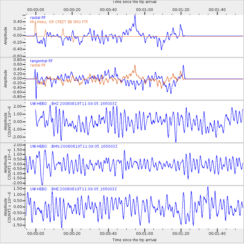
HEBO Mt. Hebo, OR CREST BB SMO - Earthquake Result Viewer
*The percent match for this event was below the threshold and hence no stack was calculated.
| Earthquake location: |
Easter Island Region |
| Earthquake latitude/longitude: |
-28.5/-112.8 |
| Earthquake time(UTC): |
2008/08/19 (232) 10:58:00 GMT |
| Earthquake Depth: |
9.0 km |
| Earthquake Magnitude: |
5.5 MB, 5.3 MS, 5.7 MW, 5.7 MW |
| Earthquake Catalog/Contributor: |
WHDF/NEIC |
|
| Network: |
UW Pacific Northwest Regional Seismic Network |
| Station: |
HEBO Mt. Hebo, OR CREST BB SMO |
| Lat/Lon: |
45.21 N/123.76 W |
| Elevation: |
875 m |
|
| Distance: |
74.1 deg |
| Az: |
352.001 deg |
| Baz: |
170.025 deg |
| Ray Param: |
$rayparam |
*The percent match for this event was below the threshold and hence was not used in the summary stack. |
|
| Radial Match: |
48.923008 % |
| Radial Bump: |
400 |
| Transverse Match: |
61.834698 % |
| Transverse Bump: |
400 |
| SOD ConfigId: |
2504 |
| Insert Time: |
2010-02-27 04:23:27.437 +0000 |
| GWidth: |
2.5 |
| Max Bumps: |
400 |
| Tol: |
0.001 |
|
Signal To Noise
| Channel | StoN | STA | LTA |
| UW:HEBO: :BHN:20080819T11:09:05.166003Z | 3.1086328 | 1.1215902E-6 | 3.6079857E-7 |
| UW:HEBO: :BHE:20080819T11:09:05.166003Z | 1.1791136 | 5.7371625E-7 | 4.865657E-7 |
| UW:HEBO: :BHZ:20080819T11:09:05.166003Z | 0.69443697 | 6.1860044E-7 | 8.9079424E-7 |
| Arrivals |
| Ps | |
| PpPs | |
| PsPs/PpSs | |


