You are here: Home > Network List > AU - Australian Seismological Centre Stations List
> Station TOO Toolangi, Victoria > Earthquake Result Viewer
TOO Toolangi, Victoria - Earthquake Result Viewer
| Earthquake location: |
South Of Java, Indonesia |
| Earthquake latitude/longitude: |
-10.0/107.2 |
| Earthquake time(UTC): |
2013/06/13 (164) 16:47:23 GMT |
| Earthquake Depth: |
9.0 km |
| Earthquake Magnitude: |
6.7 MW, 6.4 MS, 6.5 MB, 6.7 MW |
| Earthquake Catalog/Contributor: |
NEIC PDE/NEIC PDE-W |
|
| Network: |
AU Australian Seismological Centre |
| Station: |
TOO Toolangi, Victoria |
| Lat/Lon: |
37.57 S/145.49 E |
| Elevation: |
604 m |
|
| Distance: |
44.0 deg |
| Az: |
134.908 deg |
| Baz: |
298.6 deg |
| Ray Param: |
0.07219068 |
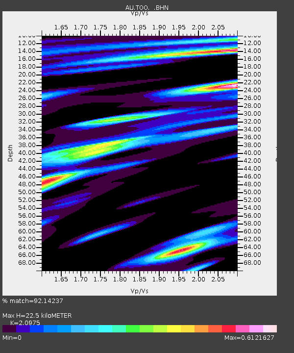
| Estimated Moho Depth: |
22.5 km |
| Estimated Crust Vp/Vs: |
2.10 |
| Assumed Crust Vp: |
6.577 km/s |
| Estimated Crust Vs: |
3.136 km/s |
| Estimated Crust Poisson's Ratio: |
0.35 |
|
| Radial Match: |
92.14237 % |
| Radial Bump: |
322 |
| Transverse Match: |
67.3793 % |
| Transverse Bump: |
400 |
| SOD ConfigId: |
512894 |
| Insert Time: |
2013-09-15 03:20:22.647 +0000 |
| GWidth: |
2.5 |
| Max Bumps: |
400 |
| Tol: |
0.001 |
|

Signal To Noise
| Channel | StoN | STA | LTA |
| AU:TOO: :BHZ:20130613T16:55:00.043999Z | 6.700087 | 3.00299E-6 | 4.4820166E-7 |
| AU:TOO: :BHN:20130613T16:55:00.043999Z | 2.12974 | 9.391727E-7 | 4.4098E-7 |
| AU:TOO: :BHE:20130613T16:55:00.043999Z | 3.785168 | 1.291732E-6 | 3.4126148E-7 |
| Arrivals |
| Ps | 4.0 SECOND |
| PpPs | 10 SECOND |
| PsPs/PpSs | 14 SECOND |


