You are here: Home > Network List > TA - USArray Transportable Network (new EarthScope stations) Stations List
> Station M53A WI Miller and Sons, Farmdale, OH, USA > Earthquake Result Viewer
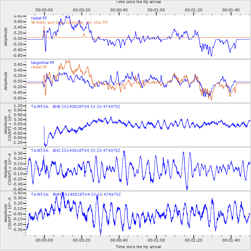
M53A WI Miller and Sons, Farmdale, OH, USA - Earthquake Result Viewer
*The percent match for this event was below the threshold and hence no stack was calculated.
| Earthquake location: |
Iran-Iraq Border Region |
| Earthquake latitude/longitude: |
32.8/47.5 |
| Earthquake time(UTC): |
2014/08/18 (230) 04:20:44 GMT |
| Earthquake Depth: |
18 km |
| Earthquake Magnitude: |
5.0 mb |
| Earthquake Catalog/Contributor: |
ISC/ISC |
|
| Network: |
TA USArray Transportable Network (new EarthScope stations) |
| Station: |
M53A WI Miller and Sons, Farmdale, OH, USA |
| Lat/Lon: |
41.44 N/80.68 W |
| Elevation: |
334 m |
|
| Distance: |
92.1 deg |
| Az: |
323.754 deg |
| Baz: |
41.499 deg |
| Ray Param: |
$rayparam |
*The percent match for this event was below the threshold and hence was not used in the summary stack. |
|
| Radial Match: |
28.598238 % |
| Radial Bump: |
400 |
| Transverse Match: |
40.168587 % |
| Transverse Bump: |
400 |
| SOD ConfigId: |
3390531 |
| Insert Time: |
2019-04-13 10:19:51.523 +0000 |
| GWidth: |
2.5 |
| Max Bumps: |
400 |
| Tol: |
0.001 |
|
Signal To Noise
| Channel | StoN | STA | LTA |
| TA:M53A: :BHZ:20140818T04:33:20.474976Z | 0.82088375 | 1.08813026E-7 | 1.3255595E-7 |
| TA:M53A: :BHN:20140818T04:33:20.474976Z | 2.1487746 | 2.5898507E-7 | 1.2052685E-7 |
| TA:M53A: :BHE:20140818T04:33:20.474976Z | 2.1113534 | 6.9347175E-7 | 3.2844892E-7 |
| Arrivals |
| Ps | |
| PpPs | |
| PsPs/PpSs | |


