You are here: Home > Network List > CB - China National Seismic Network Stations List
> Station XLT Xilinhaote,Neimeng Province > Earthquake Result Viewer
XLT Xilinhaote,Neimeng Province - Earthquake Result Viewer
| Earthquake location: |
South Of Java, Indonesia |
| Earthquake latitude/longitude: |
-10.0/107.2 |
| Earthquake time(UTC): |
2013/06/13 (164) 16:47:23 GMT |
| Earthquake Depth: |
9.0 km |
| Earthquake Magnitude: |
6.7 MW, 6.4 MS, 6.5 MB, 6.7 MW |
| Earthquake Catalog/Contributor: |
NEIC PDE/NEIC PDE-W |
|
| Network: |
CB China National Seismic Network |
| Station: |
XLT Xilinhaote,Neimeng Province |
| Lat/Lon: |
43.90 N/116.08 E |
| Elevation: |
1030 m |
|
| Distance: |
54.2 deg |
| Az: |
7.87 deg |
| Baz: |
190.754 deg |
| Ray Param: |
0.065570176 |
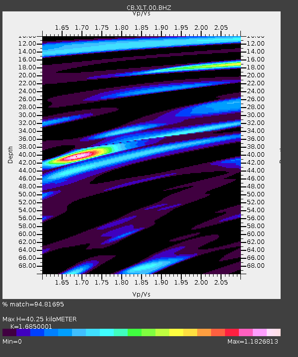
| Estimated Moho Depth: |
40.25 km |
| Estimated Crust Vp/Vs: |
1.69 |
| Assumed Crust Vp: |
6.459 km/s |
| Estimated Crust Vs: |
3.834 km/s |
| Estimated Crust Poisson's Ratio: |
0.23 |
|
| Radial Match: |
94.81695 % |
| Radial Bump: |
367 |
| Transverse Match: |
88.51727 % |
| Transverse Bump: |
400 |
| SOD ConfigId: |
512894 |
| Insert Time: |
2013-09-15 03:21:16.430 +0000 |
| GWidth: |
2.5 |
| Max Bumps: |
400 |
| Tol: |
0.001 |
|

Signal To Noise
| Channel | StoN | STA | LTA |
| CB:XLT:00:BHZ:20130613T16:56:18.379998Z | 26.554638 | 1.5412586E-6 | 5.804103E-8 |
| CB:XLT:00:BHN:20130613T16:56:18.379998Z | 16.385517 | 7.734137E-7 | 4.7201052E-8 |
| CB:XLT:00:BHE:20130613T16:56:18.379998Z | 1.9833204 | 1.0207348E-7 | 5.1465957E-8 |
| Arrivals |
| Ps | 4.5 SECOND |
| PpPs | 16 SECOND |
| PsPs/PpSs | 20 SECOND |


