You are here: Home > Network List > G - GEOSCOPE Stations List
> Station FOMA Nahampoana reservation, Fort Dauphin, Madagascar > Earthquake Result Viewer
FOMA Nahampoana reservation, Fort Dauphin, Madagascar - Earthquake Result Viewer
| Earthquake location: |
South Of Java, Indonesia |
| Earthquake latitude/longitude: |
-10.0/107.2 |
| Earthquake time(UTC): |
2013/06/13 (164) 16:47:23 GMT |
| Earthquake Depth: |
9.0 km |
| Earthquake Magnitude: |
6.7 MW, 6.4 MS, 6.5 MB, 6.7 MW |
| Earthquake Catalog/Contributor: |
NEIC PDE/NEIC PDE-W |
|
| Network: |
G GEOSCOPE |
| Station: |
FOMA Nahampoana reservation, Fort Dauphin, Madagascar |
| Lat/Lon: |
24.98 S/46.98 E |
| Elevation: |
26 m |
|
| Distance: |
58.9 deg |
| Az: |
246.913 deg |
| Baz: |
86.75 deg |
| Ray Param: |
0.062520795 |
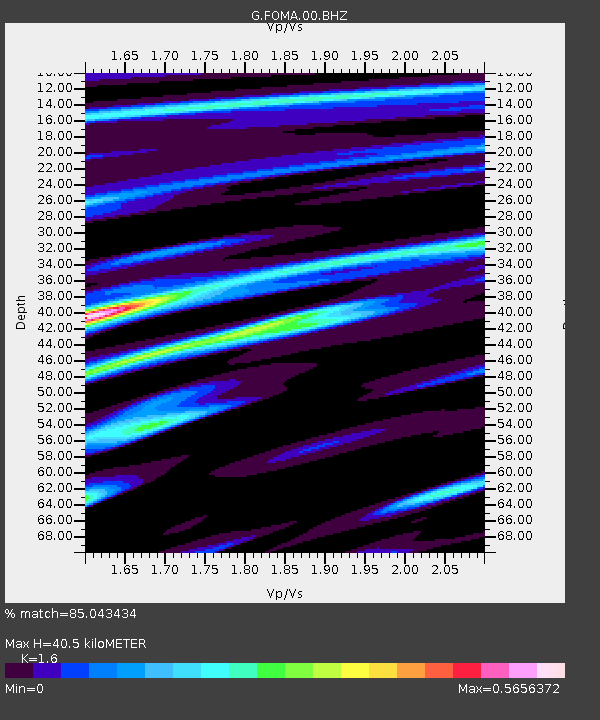
| Estimated Moho Depth: |
40.5 km |
| Estimated Crust Vp/Vs: |
1.60 |
| Assumed Crust Vp: |
6.183 km/s |
| Estimated Crust Vs: |
3.864 km/s |
| Estimated Crust Poisson's Ratio: |
0.18 |
|
| Radial Match: |
85.043434 % |
| Radial Bump: |
329 |
| Transverse Match: |
77.70547 % |
| Transverse Bump: |
400 |
| SOD ConfigId: |
512894 |
| Insert Time: |
2013-09-15 03:21:40.056 +0000 |
| GWidth: |
2.5 |
| Max Bumps: |
400 |
| Tol: |
0.001 |
|

Signal To Noise
| Channel | StoN | STA | LTA |
| G:FOMA:00:BHZ:20130613T16:56:51.749993Z | 2.2752197 | 1.3836427E-6 | 6.0813585E-7 |
| G:FOMA:00:BHN:20130613T16:56:51.749993Z | 0.6555739 | 2.637408E-7 | 4.0230523E-7 |
| G:FOMA:00:BHE:20130613T16:56:51.749993Z | 2.8588846 | 1.1921213E-6 | 4.1698826E-7 |
| Arrivals |
| Ps | 4.1 SECOND |
| PpPs | 16 SECOND |
| PsPs/PpSs | 20 SECOND |


