You are here: Home > Network List > GO - National Seismic Network of Georgia Stations List
> Station TBLG Delisi, Georgia > Earthquake Result Viewer
TBLG Delisi, Georgia - Earthquake Result Viewer
| Earthquake location: |
South Of Java, Indonesia |
| Earthquake latitude/longitude: |
-10.0/107.2 |
| Earthquake time(UTC): |
2013/06/13 (164) 16:47:23 GMT |
| Earthquake Depth: |
9.0 km |
| Earthquake Magnitude: |
6.7 MW, 6.4 MS, 6.5 MB, 6.7 MW |
| Earthquake Catalog/Contributor: |
NEIC PDE/NEIC PDE-W |
|
| Network: |
GO National Seismic Network of Georgia |
| Station: |
TBLG Delisi, Georgia |
| Lat/Lon: |
41.73 N/44.74 E |
| Elevation: |
510 m |
|
| Distance: |
76.9 deg |
| Az: |
317.036 deg |
| Baz: |
116.248 deg |
| Ray Param: |
0.05066021 |
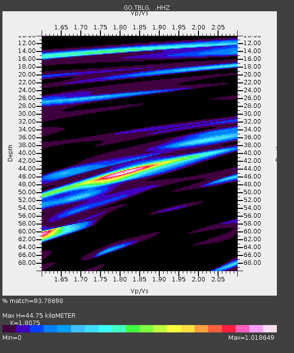
| Estimated Moho Depth: |
44.75 km |
| Estimated Crust Vp/Vs: |
1.81 |
| Assumed Crust Vp: |
6.291 km/s |
| Estimated Crust Vs: |
3.48 km/s |
| Estimated Crust Poisson's Ratio: |
0.28 |
|
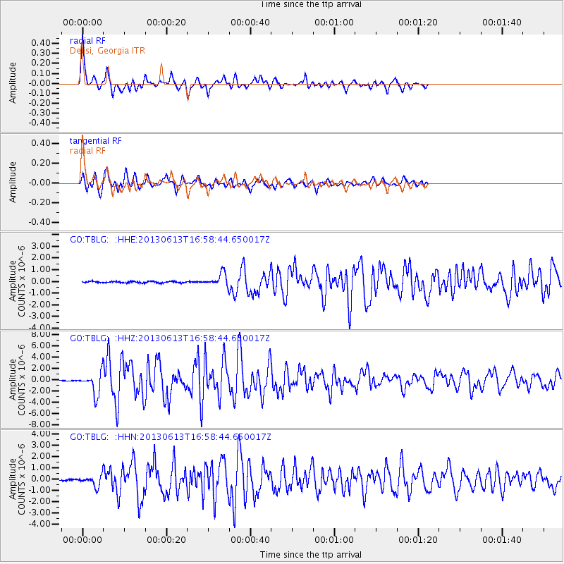
| Radial Match: |
93.78698 % |
| Radial Bump: |
321 |
| Transverse Match: |
85.76465 % |
| Transverse Bump: |
400 |
| SOD ConfigId: |
512894 |
| Insert Time: |
2013-09-15 03:22:46.314 +0000 |
| GWidth: |
2.5 |
| Max Bumps: |
400 |
| Tol: |
0.001 |
|
Signal To Noise
| Channel | StoN | STA | LTA |
| GO:TBLG: :HHZ:20130613T16:58:44.650017Z | 28.011848 | 1.9517458E-6 | 6.967572E-8 |
| GO:TBLG: :HHN:20130613T16:58:44.650017Z | 8.081661 | 4.6004348E-7 | 5.6924375E-8 |
| GO:TBLG: :HHE:20130613T16:58:44.650017Z | 9.446219 | 5.7105217E-7 | 6.045298E-8 |
| Arrivals |
| Ps | 5.9 SECOND |
| PpPs | 19 SECOND |
| PsPs/PpSs | 25 SECOND |


