You are here: Home > Network List > S - Seismographs in Schools Projects Stations List
> Station AUMTC Mt Clear College/Earth Ed, VIC, Australia > Earthquake Result Viewer
AUMTC Mt Clear College/Earth Ed, VIC, Australia - Earthquake Result Viewer
| Earthquake location: |
South Of Java, Indonesia |
| Earthquake latitude/longitude: |
-10.0/107.2 |
| Earthquake time(UTC): |
2013/06/13 (164) 16:47:23 GMT |
| Earthquake Depth: |
9.0 km |
| Earthquake Magnitude: |
6.7 MW, 6.4 MS, 6.5 MB, 6.7 MW |
| Earthquake Catalog/Contributor: |
NEIC PDE/NEIC PDE-W |
|
| Network: |
S Seismographs in Schools Projects |
| Station: |
AUMTC Mt Clear College/Earth Ed, VIC, Australia |
| Lat/Lon: |
37.61 S/143.88 E |
| Elevation: |
49 m |
|
| Distance: |
42.9 deg |
| Az: |
135.871 deg |
| Baz: |
300.279 deg |
| Ray Param: |
0.072898276 |
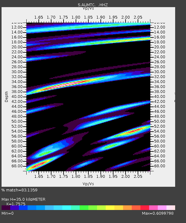
| Estimated Moho Depth: |
35.0 km |
| Estimated Crust Vp/Vs: |
1.76 |
| Assumed Crust Vp: |
6.577 km/s |
| Estimated Crust Vs: |
3.742 km/s |
| Estimated Crust Poisson's Ratio: |
0.26 |
|
| Radial Match: |
83.1359 % |
| Radial Bump: |
368 |
| Transverse Match: |
80.16821 % |
| Transverse Bump: |
400 |
| SOD ConfigId: |
512894 |
| Insert Time: |
2013-09-15 03:28:21.587 +0000 |
| GWidth: |
2.5 |
| Max Bumps: |
400 |
| Tol: |
0.001 |
|

Signal To Noise
| Channel | StoN | STA | LTA |
| S:AUMTC: :HHZ:20130613T16:54:51.189995Z | 7.29016 | 6.8992867E-6 | 9.463834E-7 |
| S:AUMTC: :HHN:20130613T16:54:51.189995Z | 1.7815971 | 2.3954078E-6 | 1.3445283E-6 |
| S:AUMTC: :HHE:20130613T16:54:51.189995Z | 2.3236465 | 3.3136212E-6 | 1.4260436E-6 |
| Arrivals |
| Ps | 4.3 SECOND |
| PpPs | 14 SECOND |
| PsPs/PpSs | 18 SECOND |


