You are here: Home > Network List > S - Seismographs in Schools Projects Stations List
> Station AUPHS Peel High School, NSW, Australia > Earthquake Result Viewer
AUPHS Peel High School, NSW, Australia - Earthquake Result Viewer
| Earthquake location: |
South Of Java, Indonesia |
| Earthquake latitude/longitude: |
-10.0/107.2 |
| Earthquake time(UTC): |
2013/06/13 (164) 16:47:23 GMT |
| Earthquake Depth: |
9.0 km |
| Earthquake Magnitude: |
6.7 MW, 6.4 MS, 6.5 MB, 6.7 MW |
| Earthquake Catalog/Contributor: |
NEIC PDE/NEIC PDE-W |
|
| Network: |
S Seismographs in Schools Projects |
| Station: |
AUPHS Peel High School, NSW, Australia |
| Lat/Lon: |
31.10 S/150.89 E |
| Elevation: |
404 m |
|
| Distance: |
45.6 deg |
| Az: |
123.981 deg |
| Baz: |
287.792 deg |
| Ray Param: |
0.07119116 |
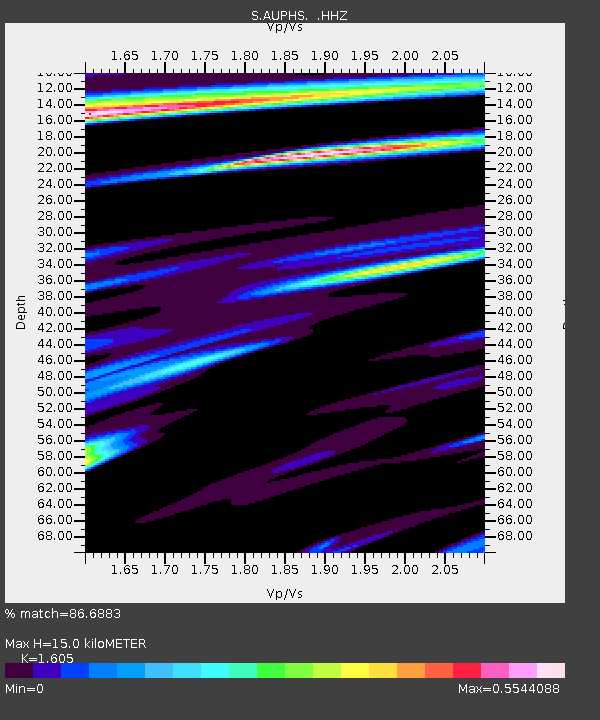
| Estimated Moho Depth: |
15.0 km |
| Estimated Crust Vp/Vs: |
1.61 |
| Assumed Crust Vp: |
6.577 km/s |
| Estimated Crust Vs: |
4.098 km/s |
| Estimated Crust Poisson's Ratio: |
0.18 |
|
| Radial Match: |
86.6883 % |
| Radial Bump: |
400 |
| Transverse Match: |
68.74486 % |
| Transverse Bump: |
394 |
| SOD ConfigId: |
512894 |
| Insert Time: |
2013-09-15 03:28:28.461 +0000 |
| GWidth: |
2.5 |
| Max Bumps: |
400 |
| Tol: |
0.001 |
|

Signal To Noise
| Channel | StoN | STA | LTA |
| S:AUPHS: :HHZ:20130613T16:55:12.58001Z | 6.1410475 | 4.8872666E-6 | 7.9583594E-7 |
| S:AUPHS: :HHN:20130613T16:55:12.58001Z | 1.3735399 | 1.0776721E-6 | 7.845947E-7 |
| S:AUPHS: :HHE:20130613T16:55:12.58001Z | 3.93751 | 3.1562427E-6 | 8.0158344E-7 |
| Arrivals |
| Ps | 1.5 SECOND |
| PpPs | 5.5 SECOND |
| PsPs/PpSs | 7.0 SECOND |


