You are here: Home > Network List > UW - Pacific Northwest Regional Seismic Network Stations List
> Station HOOD Mt Hood Meadows, OR CREST BB SMO > Earthquake Result Viewer
HOOD Mt Hood Meadows, OR CREST BB SMO - Earthquake Result Viewer
| Earthquake location: |
Eastern Siberia, Russia |
| Earthquake latitude/longitude: |
60.8/165.7 |
| Earthquake time(UTC): |
2006/05/22 (142) 11:12:00 GMT |
| Earthquake Depth: |
16 km |
| Earthquake Magnitude: |
6.0 MB, 6.7 MS, 6.6 MW, 6.5 MW |
| Earthquake Catalog/Contributor: |
WHDF/NEIC |
|
| Network: |
UW Pacific Northwest Regional Seismic Network |
| Station: |
HOOD Mt Hood Meadows, OR CREST BB SMO |
| Lat/Lon: |
45.32 N/121.65 W |
| Elevation: |
1520 m |
|
| Distance: |
43.9 deg |
| Az: |
76.299 deg |
| Baz: |
317.477 deg |
| Ray Param: |
0.07225503 |
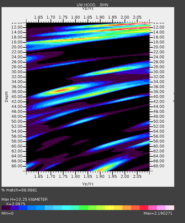
| Estimated Moho Depth: |
10.25 km |
| Estimated Crust Vp/Vs: |
2.10 |
| Assumed Crust Vp: |
6.597 km/s |
| Estimated Crust Vs: |
3.145 km/s |
| Estimated Crust Poisson's Ratio: |
0.35 |
|
| Radial Match: |
86.8661 % |
| Radial Bump: |
400 |
| Transverse Match: |
72.35872 % |
| Transverse Bump: |
400 |
| SOD ConfigId: |
5423 |
| Insert Time: |
2010-02-27 04:23:54.597 +0000 |
| GWidth: |
2.5 |
| Max Bumps: |
400 |
| Tol: |
0.001 |
|
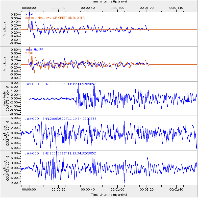
Signal To Noise
| Channel | StoN | STA | LTA |
| UW:HOOD: :BHN:20060522T11:19:34.920985Z | 2.7225742 | 1.3177978E-6 | 4.840264E-7 |
| UW:HOOD: :BHE:20060522T11:19:34.920985Z | 2.2654312 | 1.3452931E-6 | 5.938353E-7 |
| UW:HOOD: :BHZ:20060522T11:19:34.920985Z | 10.551538 | 2.8177049E-6 | 2.6704208E-7 |
| Arrivals |
| Ps | 1.8 SECOND |
| PpPs | 4.5 SECOND |
| PsPs/PpSs | 6.3 SECOND |


