You are here: Home > Network List > IU - Global Seismograph Network (GSN - IRIS/USGS) Stations List
> Station HNR Honiara, Solomon Islands > Earthquake Result Viewer
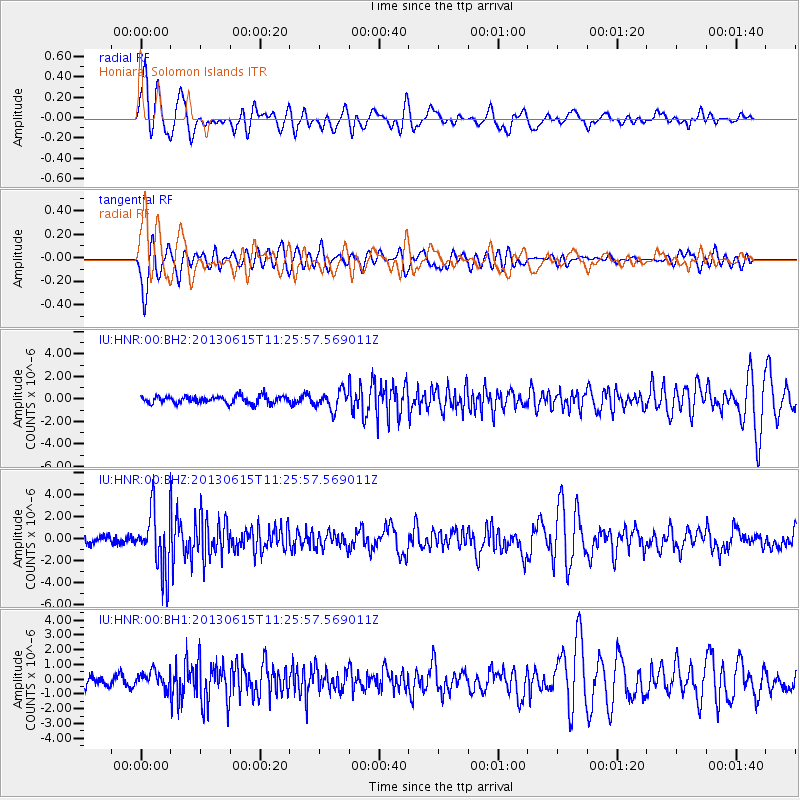
HNR Honiara, Solomon Islands - Earthquake Result Viewer
*The percent match for this event was below the threshold and hence no stack was calculated.
| Earthquake location: |
South Of Kermadec Islands |
| Earthquake latitude/longitude: |
-33.9/179.4 |
| Earthquake time(UTC): |
2013/06/15 (166) 11:20:36 GMT |
| Earthquake Depth: |
195 km |
| Earthquake Magnitude: |
6.0 MW, 5.5 MB, 6.0 MW |
| Earthquake Catalog/Contributor: |
NEIC PDE/NEIC PDE-W |
|
| Network: |
IU Global Seismograph Network (GSN - IRIS/USGS) |
| Station: |
HNR Honiara, Solomon Islands |
| Lat/Lon: |
9.44 S/159.95 E |
| Elevation: |
100 m |
|
| Distance: |
30.2 deg |
| Az: |
319.167 deg |
| Baz: |
146.53 deg |
| Ray Param: |
$rayparam |
*The percent match for this event was below the threshold and hence was not used in the summary stack. |
|
| Radial Match: |
77.58842 % |
| Radial Bump: |
400 |
| Transverse Match: |
71.998085 % |
| Transverse Bump: |
400 |
| SOD ConfigId: |
512894 |
| Insert Time: |
2013-09-15 03:38:34.821 +0000 |
| GWidth: |
2.5 |
| Max Bumps: |
400 |
| Tol: |
0.001 |
|
Signal To Noise
| Channel | StoN | STA | LTA |
| IU:HNR:00:BHZ:20130615T11:25:57.569011Z | 10.339648 | 2.7278797E-6 | 2.6382713E-7 |
| IU:HNR:00:BH1:20130615T11:25:57.569011Z | 2.1466482 | 5.571187E-7 | 2.5952957E-7 |
| IU:HNR:00:BH2:20130615T11:25:57.569011Z | 2.4936664 | 8.1706565E-7 | 3.2765635E-7 |
| Arrivals |
| Ps | |
| PpPs | |
| PsPs/PpSs | |


