You are here: Home > Network List > TA - USArray Transportable Network (new EarthScope stations) Stations List
> Station M53A WI Miller and Sons, Farmdale, OH, USA > Earthquake Result Viewer
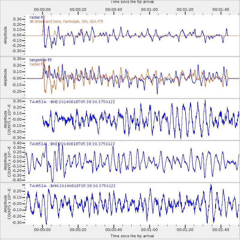
M53A WI Miller and Sons, Farmdale, OH, USA - Earthquake Result Viewer
*The percent match for this event was below the threshold and hence no stack was calculated.
| Earthquake location: |
Iran-Iraq Border Region |
| Earthquake latitude/longitude: |
32.7/47.8 |
| Earthquake time(UTC): |
2014/08/18 (230) 05:25:50 GMT |
| Earthquake Depth: |
10 km |
| Earthquake Magnitude: |
6.0 M |
| Earthquake Catalog/Contributor: |
NEIC PDE/NEIC ALERT |
|
| Network: |
TA USArray Transportable Network (new EarthScope stations) |
| Station: |
M53A WI Miller and Sons, Farmdale, OH, USA |
| Lat/Lon: |
41.44 N/80.68 W |
| Elevation: |
334 m |
|
| Distance: |
92.3 deg |
| Az: |
323.88 deg |
| Baz: |
41.407 deg |
| Ray Param: |
$rayparam |
*The percent match for this event was below the threshold and hence was not used in the summary stack. |
|
| Radial Match: |
65.02678 % |
| Radial Bump: |
400 |
| Transverse Match: |
64.522484 % |
| Transverse Bump: |
368 |
| SOD ConfigId: |
3390531 |
| Insert Time: |
2019-04-13 10:25:26.838 +0000 |
| GWidth: |
2.5 |
| Max Bumps: |
400 |
| Tol: |
0.001 |
|
Signal To Noise
| Channel | StoN | STA | LTA |
| TA:M53A: :BHZ:20140818T05:38:30.375012Z | 1.328776 | 1.7199193E-7 | 1.2943636E-7 |
| TA:M53A: :BHN:20140818T05:38:30.375012Z | 1.1185794 | 1.666699E-7 | 1.4900141E-7 |
| TA:M53A: :BHE:20140818T05:38:30.375012Z | 1.2496881 | 9.304082E-8 | 7.445123E-8 |
| Arrivals |
| Ps | |
| PpPs | |
| PsPs/PpSs | |


