You are here: Home > Network List > UW - Pacific Northwest Regional Seismic Network Stations List
> Station HOOD Mt Hood Meadows, OR CREST BB SMO > Earthquake Result Viewer
HOOD Mt Hood Meadows, OR CREST BB SMO - Earthquake Result Viewer
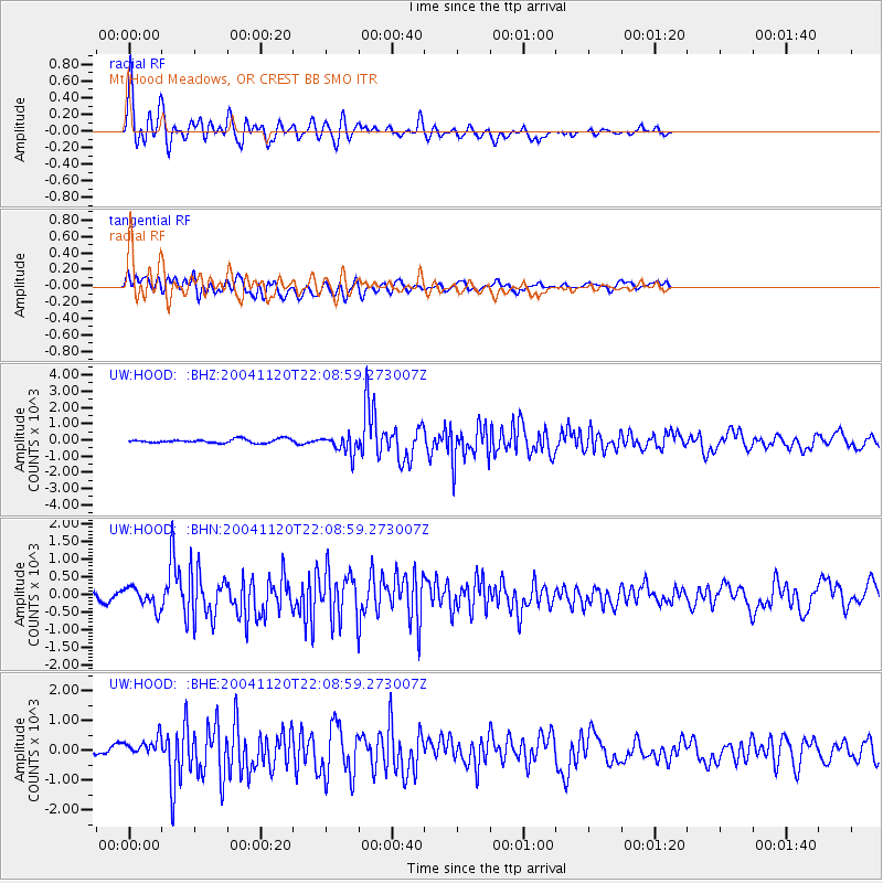
| Earthquake location: |
Near Coast Of Guatemala |
| Earthquake latitude/longitude: |
13.4/-90.1 |
| Earthquake time(UTC): |
2004/11/20 (325) 22:01:45 GMT |
| Earthquake Depth: |
41 km |
| Earthquake Magnitude: |
5.6 MB, 6.0 MS, 6.3 MW, 6.2 MW |
| Earthquake Catalog/Contributor: |
WHDF/NEIC |
|
| Network: |
UW Pacific Northwest Regional Seismic Network |
| Station: |
HOOD Mt Hood Meadows, OR CREST BB SMO |
| Lat/Lon: |
45.32 N/121.65 W |
| Elevation: |
1520 m |
|
| Distance: |
41.6 deg |
| Az: |
326.171 deg |
| Baz: |
129.829 deg |
| Ray Param: |
0.07358855 |
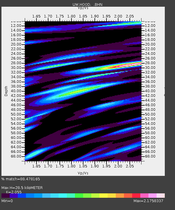
| Estimated Moho Depth: |
28.5 km |
| Estimated Crust Vp/Vs: |
2.06 |
| Assumed Crust Vp: |
6.597 km/s |
| Estimated Crust Vs: |
3.21 km/s |
| Estimated Crust Poisson's Ratio: |
0.34 |
|
| Radial Match: |
88.478165 % |
| Radial Bump: |
400 |
| Transverse Match: |
66.66099 % |
| Transverse Bump: |
400 |
| SOD ConfigId: |
2459 |
| Insert Time: |
2010-02-27 04:24:15.298 +0000 |
| GWidth: |
2.5 |
| Max Bumps: |
400 |
| Tol: |
0.001 |
|
Signal To Noise
| Channel | StoN | STA | LTA |
| UW:HOOD: :BHN:20041120T22:08:59.273007Z | 1.2270408 | 296.46118 | 241.60661 |
| UW:HOOD: :BHE:20041120T22:08:59.273007Z | 1.7536786 | 360.69702 | 205.68024 |
| UW:HOOD: :BHZ:20041120T22:08:59.273007Z | 4.6962595 | 565.1829 | 120.34747 |
| Arrivals |
| Ps | 4.8 SECOND |
| PpPs | 12 SECOND |
| PsPs/PpSs | 17 SECOND |


