You are here: Home > Network List > AK - Alaska Regional Network Stations List
> Station KIAG Kiagna River, AK, USA > Earthquake Result Viewer
KIAG Kiagna River, AK, USA - Earthquake Result Viewer
| Earthquake location: |
Crete, Greece |
| Earthquake latitude/longitude: |
34.4/25.0 |
| Earthquake time(UTC): |
2013/06/15 (166) 16:11:02 GMT |
| Earthquake Depth: |
10 km |
| Earthquake Magnitude: |
6.2 MW, 6.0 MB, 6.0 MS, 6.1 MW |
| Earthquake Catalog/Contributor: |
NEIC PDE/NEIC PDE-W |
|
| Network: |
AK Alaska Regional Network |
| Station: |
KIAG Kiagna River, AK, USA |
| Lat/Lon: |
60.92 N/142.36 W |
| Elevation: |
1773 m |
|
| Distance: |
84.5 deg |
| Az: |
353.845 deg |
| Baz: |
10.457 deg |
| Ray Param: |
0.0454685 |
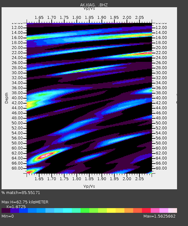
| Estimated Moho Depth: |
62.75 km |
| Estimated Crust Vp/Vs: |
1.67 |
| Assumed Crust Vp: |
6.566 km/s |
| Estimated Crust Vs: |
3.926 km/s |
| Estimated Crust Poisson's Ratio: |
0.22 |
|
| Radial Match: |
85.55171 % |
| Radial Bump: |
400 |
| Transverse Match: |
78.14722 % |
| Transverse Bump: |
400 |
| SOD ConfigId: |
512894 |
| Insert Time: |
2013-09-15 03:47:30.931 +0000 |
| GWidth: |
2.5 |
| Max Bumps: |
400 |
| Tol: |
0.001 |
|

Signal To Noise
| Channel | StoN | STA | LTA |
| AK:KIAG: :BHZ:20130615T16:23:03.768005Z | 10.8050375 | 5.5127543E-7 | 5.1020223E-8 |
| AK:KIAG: :BHN:20130615T16:23:03.768005Z | 4.46866 | 2.738312E-7 | 6.127815E-8 |
| AK:KIAG: :BHE:20130615T16:23:03.768005Z | 1.4808705 | 7.544852E-8 | 5.0948763E-8 |
| Arrivals |
| Ps | 6.6 SECOND |
| PpPs | 25 SECOND |
| PsPs/PpSs | 31 SECOND |


