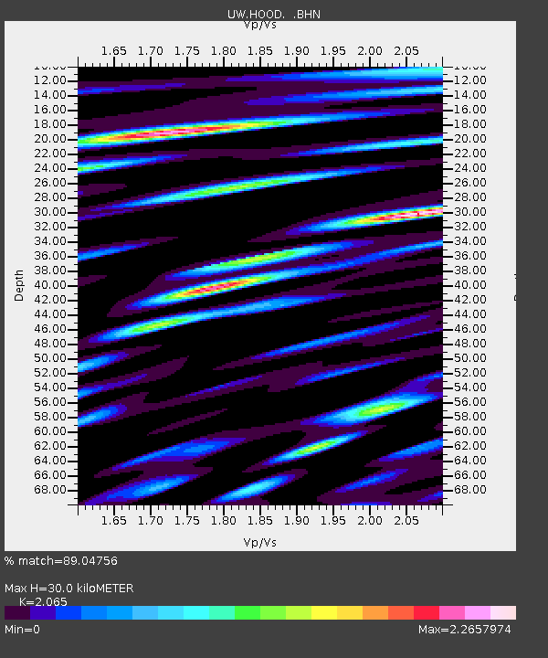
HOOD Mt Hood Meadows, OR CREST BB SMO - Earthquake Result Viewer
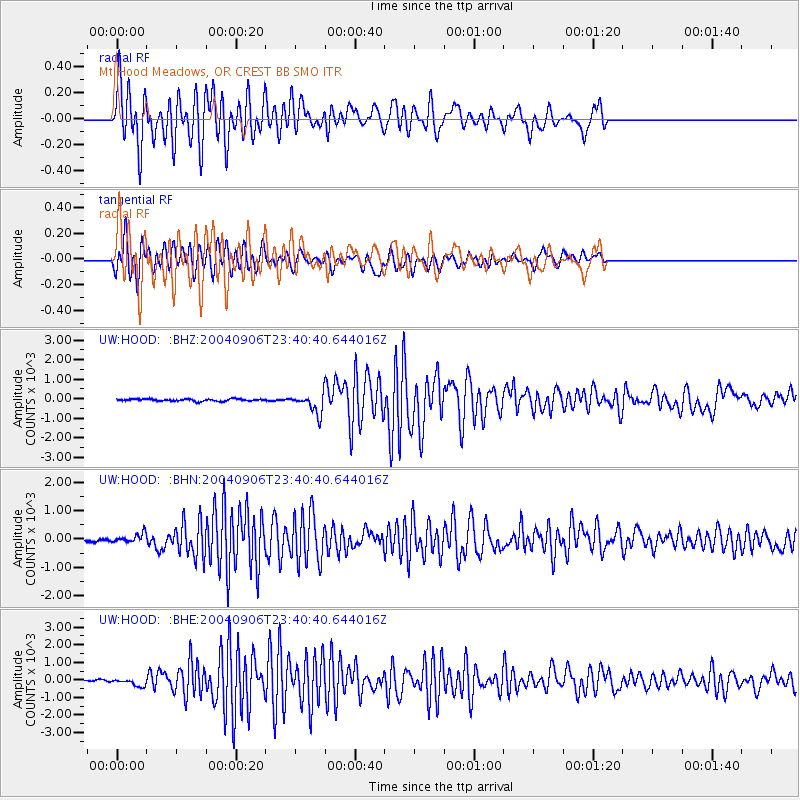
Earthquake location: Near S. Coast Of Honshu, Japan
Earthquake latitude/longitude: 33.2/137.2
Earthquake time(UTC): 2004/09/06 (250) 23:29:35 GMT
Earthquake Depth: 10 km
Earthquake Magnitude: 6.4 MB, 6.3 MS, 6.7 MW, 6.5 MW
Earthquake Catalog/Contributor: WHDF/NEIC
Network: UW Pacific Northwest Regional Seismic Network
Station: HOOD Mt Hood Meadows, OR CREST BB SMO
Lat/Lon: 45.32 N/121.65 W
Elevation: 1520 m
Distance: 74.2 deg
Az: 46.008 deg
Baz: 301.247 deg
Ray Param: 0.052490637
Estimated Moho Depth: 30.0 km
Estimated Crust Vp/Vs: 2.07
Assumed Crust Vp: 6.597 km/s
Estimated Crust Vs: 3.195 km/s
Estimated Crust Poisson's Ratio: 0.35
Radial Match: 89.04756 %
Radial Bump: 400
Transverse Match: 85.85777 %
Transverse Bump: 400
SOD ConfigId: 2459
Insert Time: 2010-02-27 04:24:36.333 +0000
GWidth: 2.5
Max Bumps: 400
Tol: 0.001

Signal To Noise

ChannelStoNSTALTA
UW:HOOD: :BHN:20040906T23:40:40.644016Z2.617466149.1157456.9695
UW:HOOD: :BHE:20040906T23:40:40.644016Z3.2021654198.5797162.014194
UW:HOOD: :BHZ:20040906T23:40:40.644016Z9.384148497.2893452.99249
Arrivals
Ps5.0 SECOND
PpPs14 SECOND
PsPs/PpSs19 SECOND