You are here: Home > Network List > UW - Pacific Northwest Regional Seismic Network Stations List
> Station HOOD Mt Hood Meadows, OR CREST BB SMO > Earthquake Result Viewer
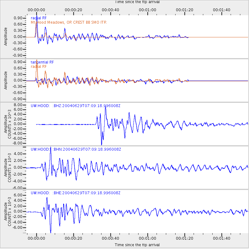
HOOD Mt Hood Meadows, OR CREST BB SMO - Earthquake Result Viewer

| Earthquake location: |
Off Coast Of Costa Rica |
| Earthquake latitude/longitude: |
10.7/-87.0 |
| Earthquake time(UTC): |
2004/06/29 (181) 07:01:30 GMT |
| Earthquake Depth: |
9.0 km |
| Earthquake Magnitude: |
5.8 MB, 5.8 MS, 6.3 MW, 6.1 MW |
| Earthquake Catalog/Contributor: |
WHDF/NEIC |
|
| Network: |
UW Pacific Northwest Regional Seismic Network |
| Station: |
HOOD Mt Hood Meadows, OR CREST BB SMO |
| Lat/Lon: |
45.32 N/121.65 W |
| Elevation: |
1520 m |
|
| Distance: |
45.4 deg |
| Az: |
325.769 deg |
| Baz: |
128.412 deg |
| Ray Param: |
0.07128796 |
| Estimated Moho Depth: |
28.25 km |
| Estimated Crust Vp/Vs: |
2.07 |
| Assumed Crust Vp: |
6.597 km/s |
| Estimated Crust Vs: |
3.191 km/s |
| Estimated Crust Poisson's Ratio: |
0.35 |
|
| Radial Match: |
96.75425 % |
| Radial Bump: |
387 |
| Transverse Match: |
89.03486 % |
| Transverse Bump: |
400 |
| SOD ConfigId: |
2459 |
| Insert Time: |
2010-02-27 04:24:44.819 +0000 |
| GWidth: |
2.5 |
| Max Bumps: |
400 |
| Tol: |
0.001 |
|
Signal To Noise
| Channel | StoN | STA | LTA |
| UW:HOOD: :BHN:20040629T07:09:18.996008Z | 10.189147 | 589.784 | 57.88355 |
| UW:HOOD: :BHE:20040629T07:09:18.996008Z | 8.541047 | 864.1882 | 101.180595 |
| UW:HOOD: :BHZ:20040629T07:09:18.996008Z | 38.02032 | 1519.0726 | 39.954227 |
| Arrivals |
| Ps | 4.8 SECOND |
| PpPs | 12 SECOND |
| PsPs/PpSs | 17 SECOND |


